Displaying 1 - 6 of 6
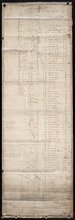
Plan of Lot or Township No. 66: from the latest Surveys by Jos. Ball Surveyor General's Office…
Description: Plan of Lot 66. Gives list of settlers. The map shows Lot 66 divided into numbered parcels of land. Along the side there is a corresponding list of parcel numbers and settlers' names handwritten… more
Province: Prince Edward Island
Type: cadastral maps
Date Created: 1856-08-04
Plan of Lot or Township No. 66 from actual survey.
Description: Plan of Lot or Township No. 66 from actual survey. Rolled paper on fabric backing; handwriting on verso. The map shows Lot 66 divided into parcels of land with the names of residents and their… more
Province: Prince Edward Island
Type: cadastral maps
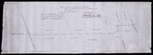
Plan shewing the situation of a new line of road from Baldwin's Road, Lot 51 to Brother's…
Description: Plan showing the situation of a new line of road from Baldwin's Road, Lot 51 to Brother's Road, Lot 66 more
Province: Prince Edward Island
Type: cadastral maps
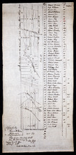
Plan of Lot or Township No. 66: from the latest Surveys by Jos. Ball S. G. Surveyor General's…
Description: Plan of Lot 66. Copied by Thomas W. May, July 8, 1921. This copy of an earlier map shows Lot 66 divided into numbered parcels of land. A list down the right side gives the residents' names and… more
Province: Prince Edward Island
Type: cadastral maps
Date Created: 1856-08-04
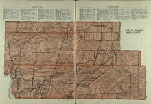
Lots 51, 52, and 66: Kings County
Description: The map shows lots 51, 52, and 66 in Kings County. Shown are Brown Creek, Montague River, Landowners, acreage, roads, and railroads.
Publisher: Cummins Map Co.
Province: Prince Edward Island
Type: cadastral maps
Date Issued (Source): 1927
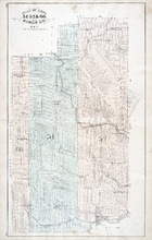
Plan of Lots 51, 52, & 66: Kings Co., P.E.I.
Description: The map shows lots 51, 52, & 66 in Kings county. Shown are roads, railroads and stations, landowners and acreage, streams, rivers, post offices, mills, and churches. Graphic compass.
Publisher: J. H. Meacham & company
Province: Prince Edward Island
Type: cadastral maps
Date Issued (Source): 1880