Displaying 1 - 8 of 8
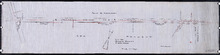
Plan showing 0.604 acres of land acquired from Leo Praught, Lot 50, for the Provincial Highway
Description: Plan showing 0.604 acres of land acquired from Leo Praught, Lot 50, for the Provincial Highway. The map shows measurements, acres, some residents and roads and where those roads lead too.
Province: Prince Edward Island
Type: cadastral maps
Date Created: 1939-05
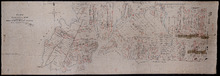
Plan of Township No. 50, the Property of Maria Susanna Matilda Fanning
Description: Plan of Lot 50, the property of Maria Susanna Matilda Fanning. Shows names of residents, acreage, and land conveyance references, bodies of water such as rivers (Vernon), bays (Pownal), and roads.… more
Province: Prince Edward Island
Type: cadastral maps

Plan of certain tracts of land at or near Orwell according to registered deeds, and two surveys…
Description: Plan of part of Lot 50. Clark's Corner, Orwell. Shows certain tracts of land at or near Orwell according to registered deeds and two surveys. Rough copy included. more
Province: Prince Edward Island
Type: cadastral maps
Plan of part of Lot 50
Description: Plan of part of Lot 50 (No.13). Area east of the Murray Harbour Road, north of the Dundee Road, and south of Georgetown Road. Shows names of residents.
Province: Prince Edward Island
Type: cadastral maps
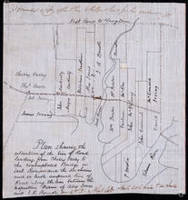
Plan shewing the situation of the line of road leading from Cherry Valley to the contemplated…
Description: Plan showing the situation of the line of road leading from Cherry Valley to the contemplated bridge on Seal River and the 24 chains and 50 links unopened line of road along the line between the… more
Province: Prince Edward Island
Type: cadastral maps
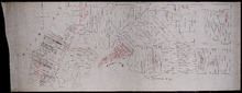
Plan of Lot 50
Description: Plan of Lot 50. Shows names of residents, acreage, and some land conveyance references, roads, and bodies of water such as rivers (Orwell), and bays (Pownal).
Province: Prince Edward Island
Type: cadastral maps
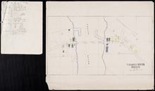
Vernon River Bridge, Lot 50
Description: This item consists of a fire insurance plan of the community of Vernon River Bridge and an accompanying handwritten text document. The map of Vernon River shows the community divided into numbered… more
Province: Prince Edward Island
Type: fire insurance maps
Date Issued (Source): 1888

Plan of Township No. 50 The Estate of the Misses[?] Fanning, Prince Edward Island: From actual…
Description: Plan of Lot 50. Fanning Estate. The map shows lots, residents, bodies of water and roads.
Province: Prince Edward Island
Type: cadastral maps