Displaying 1 - 14 of 14

Map of Southport and Rosebank, Prince Edward Island: Drawn by C.D. Lambown Sept. 26, 1953
Description: Map of Southport and Rosebank, Lot.48. Shows names of residents, acreage, cities and towns, and Hillsborough River.
Province: Prince Edward Island
Type: cadastral maps
Date Created: 1953-09-26

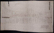
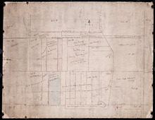
Plan of Township No. 48: compiled during the year 1915 from plans on file in the Land Office and…
Description: Plan of Lot 48 compiled during the year 1915 from plans on file in the Land Office and Registry Office and from the chart of Charlottetown Harbour supplemented by the descriptions in the leases and… more
Province: Prince Edward Island
Type: cadastral maps
Date Created: 1915
Plan of Lot 48 east of Fullerton's Creek
Description: Plan of that part of Lot 48 east of Fullerton's Creek. Shows names of residents and acreage. (No.13 in Plan Book) (Also, No.924) more
Province: Prince Edward Island
Type: cadastral maps
Date Created: 1874-01
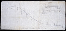
Plan of the division line between Lots 48 and 49
Description: Plan of the division line between Lots 48 and 49. The map shows lots, residents, roads, and bodies of water.
Province: Prince Edward Island
Type: cadastral maps
Date Created: 1841-06
Plan showing the point of commencement of the division line between Lots 48 and 49, established by…
Description: Plan showing the point of commencement of the division line between Lots 48 and 49, established by the Commissioners under the Boundary Bill, July 30, 1840. The map shows lots, residents, roads,… more
Province: Prince Edward Island
Type: cadastral maps
Date Created: 1840-08
Plan of the road from Kelly's Cove to the line between John F. Baker and Frank Bovyer thro…
Description: Plan of the road from Kelly's Cove to the line between John F. Baker and Frank Bovyer through Bunbury, Lot 48. Ordered to be widened. The map shows lots, residents, roads, and water. more
Province: Prince Edward Island
Type: cadastral maps

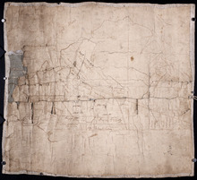
Plan of Lot 48
Description: Plan of Lot 48. Incomplete. Shows names of residents, acreage, and some land conveyance references for the eastern part of the lot, roads and bodies of water.
Province: Prince Edward Island
Type: cadastral maps

Plan of Lot 48 (No.2)
Description: Plan of Lot 48 (No.2). Shows property of Peter Stewart, Tho. Wright, Tho. DesBrisay, Chas. Stewart, and James Park. Also shows property leased to R. Stewart. Gives location of Battery and the acreage… more
Province: Prince Edward Island
Type: cadastral maps

Incomplete part of Lot 48 (No.130)
Description: Incomplete part of Lot 48 (No.130). Shows the following estates: DesBrisay, Crooke, Cummingham, Cunard, and Lawton. Also gives the names of some residents.
Province: Prince Edward Island
Type: cadastral maps
Plan of the southwestern part of Lot 48 (No.3)
Description: Plan of the southwestern part of Lot 48 (No.3). Gives names of some residents. Shows the location of York Battery and the Reserved Land at Crab Point.
Province: Prince Edward Island
Type: cadastral maps
Map of Lot Forty-Eight: J.H. Meachams and Co. Atlas
Description: Map of Lot 48. Draft for Meacham's Atlas. Also includes inset map of Southport or Stratford (scale: 6 chains/inch). Shows the Charlottetown Royalty, bodies of water such as rivers, and lakes,… more
Province: Prince Edward Island
Type: cadastral maps

Partial plan of Lot 48
Description: Partial plan of Lot 48. Mainly outline. Shows names of some residents in southern half of Lot. The map shows residents and lots, and roads.
Province: Prince Edward Island
Type: cadastral maps
Plan of the eastern part of Lot 48 and the southern part of Lot 36
Description: Plan of the eastern part of Lot 48 and the southern part of Lot 36. Area around the Monaghan Road. Shows names of residents. (No.132)
Province: Prince Edward Island
Type: cadastral maps

Plan of the Northern Moiety of Lot or Township No. 48 in Prince Edward Island, Copied from the Plan…
Description: Plan of the northern moiety of Lot 48 (No.129). Shows the property of Miss Frances Crooke, R.G. Cuninghame, Theo. Desbrisay, and the Misses Lawton. The map shows lots, residents, roads, and bodies of… more
Province: Prince Edward Island
Type: cadastral maps
Date Created: 1836