Displaying 1 - 5 of 5

Plan of the Eastern Moiety of Township No. 46 East Parish. Kings County. P. E. Island.
Description: Plan of the eastern moiety of Lot 46, East Parish, Kings Co. (No.125). Cunard Estate. Shows names of residents and acreage, roads, and the Gulf of St. Lawrence. One of the plans referred to in the… more
Province: Prince Edward Island
Type: cadastral maps
Date Created: 1866

A Plan of the Eastern Moiety of Township No. 46 From the Survey of H. J. Cundall L. S. By Owen…
Description: Plan of the eastern half of Lot 46. (No.126) created by Owen Curtis and R.A. Strong from the survey by H.J. Cundall. Shows names of residents, acreage, and land conveyance references, bodies of water… more
Province: Prince Edward Island
Type: cadastral maps

Lot No. 46
Description: Plan of Lot 46 (No.1) divided into two parts and drawn for in Council, Oct. 24, 1786. The map shows Lot 46 divided into two parts--Division No. 1 (west) and Division No. 2 (east)--of 10,000 acres… more
Province: Prince Edward Island
Type: cadastral maps
Date Created: 1786-10-24
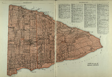
Lots 46 and 47 : Kings County
Description: The map shows lots 46 and 47 in Kings county. Shown are the Gulf of St. Lawrence, points, rivers, coves, landowners, acreage, roads, railroads, lakes, and sand.
Publisher: Cummins Map Co.
Province: Prince Edward Island
Type: cadastral maps
Date Issued (Source): 1927
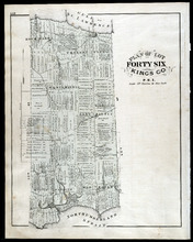
Plan of Lot Fourty Six: Kings Co., P.E.I.
Description: The map shows lot 46 in Kings county. Shown are a gulf, straits, pond, roads, landowners and acreage, school houses, post offices, mills, and sand. Compass.
Publisher: J. H. Meacham & company
Province: Prince Edward Island
Type: cadastral maps
Date Issued (Source): 1880