Displaying 1 - 5 of 5

Plan of Lot or Township No. 41: From The Latest Surveys By Joseph Ball S.G., Copied by O. Curtis
Description: Plan of Lot 41 (No.111). Showing residents. Surveyed by Joseph Ball. Plan copied by Owen Curtis.
Province: Prince Edward Island
Type: cadastral maps

Plan of Lot 41
Description: Plan of Lot 41. Shows names of some residents. The map also shows St. Peters Bay and the Gulf of St. Lawrence.
Province: Prince Edward Island
Type: cadastral maps
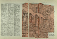
Lots 40 and 41: Kings County
Description: The map shows lots 40 and 41 in Kings county. Shown are the Gulf of St. Lawrence, St. Peters Bay, landowners, acreage, roads, and railroads.
Publisher: Cummins Map Co.
Province: Prince Edward Island
Type: cadastral maps
Date Issued (Source): 1927
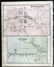
Kensington, Lot 19: St. Peters, Lot 41
Description: The map shows lot 19 in Kensington. Shown are a school house, a hall, roads, landowners, railroad and depot grounds, businesses and churches. Compass.
Publisher: J. H. Meacham & company
Province: Prince Edward Island
Type: cadastral maps
Date Issued (Source): 1880
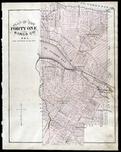
Plan of Lot Forty One: Kings Co., P.E.I.
Description: The map shows lot 41 in Kings county. Shown are St. Peters bay, river, gulf, roads, landowners and acreage, railroad and station, post offices, mills, schools, and churches. Compass.
Publisher: J. H. Meacham & company
Province: Prince Edward Island
Type: cadastral maps
Date Issued (Source): 1880