Displaying 1 - 12 of 12

Plan of Lot or Township No 4, in P.E. Island: The shores and the division Lines coloured according…
Description: Plan of Lot 4. The shores and the division lines colored to yellow are according to actual survey. Shows names of some residents, acreage, roads, and bodies of water such as rivers.
Province: Prince Edward Island
Type: cadastral maps

A Plan of Township No 4 Part of the Cunard Estate Prince County P.E.Island
Description: A plan of Lot 4, part of the Cunard Estate. Copied from plans in the Public Lands Department. The map shows lots, residents, bodies of water such as rivers, railways, and roads.
Province: Prince Edward Island
Type: cadastral maps
Date Created: 1885-06

Plan of Township No. 4: Compiled from the plans, leases, deeds, and other documents on file in the…
Description: The map shows Lot 4 divided into parcels of land with the names of residents, their acreage amounts and land conveyance references. The map shows roads in a light brown colour. It shows the P.E.I.… more
Province: Prince Edward Island
Type: cadastral maps
Date Created: 1911-06
Sketch of parts of Lots 4 and 5
Description: Sketch of parts of Lots 4 and 5. Area along Mill River(?). Shown are lots, and water.
Province: Prince Edward Island
Type: cadastral maps

A Trace of West Coast, Prince Edward Island: from the Survey by Capt. Bayfield, R.N. furnished at…
Description: Plan of the West Coast of Prince Edward Island from the survey by Capt. Bayfield furnished at the request of a Committee of the House of Assembly, March 18, 1842. The coast line marked in red has… more
Province: Prince Edward Island
Type: cadastral maps
Date Created: 1842

Plan of Alberton: Surveyed by John Ball, Land Surveyor
Description: Plan of part of Alberton, Lot 4. Shows names of residents and land conveyance references, bodies of water such as bays, and creeks, and roads.
Province: Prince Edward Island
Type: cadastral maps
Date Created: 1871-08
Lots 4 : Prince county
Description: The map shows Lots 4
Publisher: Cummins Map Co.
Province: Prince Edward Island
Type: cadastral maps
Date Issued (Source): 1927
Rural Directory - Lots 4 - 6, Prince County
Description: A directory listing of residents of lots 4, 5, and 6.
Publisher: Cummins Map Co.
Province: Prince Edward Island
Type: text
Date Issued (Source): 1927

Plan of Lots Two : Prince Co., P.E.I.
Description: Map showing lots 2
Publisher: J. H. Meacham & company
Province: Prince Edward Island
Type: cadastral maps
Date Issued (Source): 1880

Tignish, Prince Co.: Campbellton
Description: The map shows Lot 1 in Tignish, Prince county. Shown are roads, landowners and acreage, a church, chapel, and convent, a cemetery, railroad and station, grammar school, business, and houses. Compass.
Publisher: J. H. Meacham & company
Province: Prince Edward Island
Type: cadastral maps
Date Issued (Source): 1880

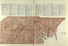
Plan of Lot Four : Prince Co., P.E.I.
Description: Map showing lots four
Publisher: J. H. Meacham & company
Province: Prince Edward Island
Type: cadastral maps
Date Issued (Source): 1880
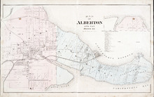
Map of Alberton Lots 4 & 5: Prince Co., P.E.I.
Description: The map shows lots 4 & 5 in the town of Alberton, Prince county. Shown are rivers, creeks, lakes, wharfs, shipyard, roads, railroad, landowners and acreage, mills, churches and cemetery. Compass… more
Publisher: J. H. Meacham & company
Province: Prince Edward Island
Type: cadastral maps
Date Issued (Source): 1880