Displaying 1 - 6 of 6
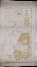
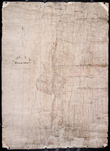
Plan of St. Martins, Township No. 35; Plan of 320 1/2 Acres of Land "Arisaig", Township…
Description: Plan of St. Martins, Lot 35 (south of the Hillsborough River). Also a plan of Arisaig, 320 and a half acres of land on Lot 35 and a plan of that part of Lot 36 north of the Hillsborough River.
Province: Prince Edward Island
Type: cadastral maps
Date Created: 1873
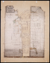
Plan of Fort Augustus and Monaghan Settlement in Township Number 36, in Prince Edward Island, the…
Description: Plan of Fort Augustus and Monaghan Settlement in Lot 36, the property of the Rev. John McDonald. Shows names of residents and acreage, bodies of water such as rivers (Hillsborough), ponds, roads, and… more
Province: Prince Edward Island
Type: cadastral maps
Date Created: 1840
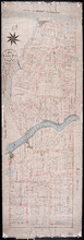
Plan of Township No. 36 Comprising the Estates of Helen Jane MacDonald, Rev. J. A. S. MacDonald and…
Description: Plan of Lot 36 (No.100) comprising the Estates of Helen Jane MacDonald, Rev. J.A.S. MacDonald, and W.C. MacDonald. Shows names of residents, acreage, and land conveyance references, bodies of water… more
Province: Prince Edward Island
Type: cadastral maps
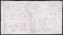
Plan if the Southren Moiety of Township No 36 Part of the Estate of the Rev: John Alister Somerlet…
Description: Plan of the southern moiety of Lot 36 (No.2). Part of the estate of the Rev. John Alister Somerlet MacDonald. From a tracing by W.C. Harris. The map shows lots, residents, a pond, and roads.
Province: Prince Edward Island
Type: cadastral maps
Date Created: 1878-03-22
A Plan of Glenaladale, The property of the Heirs of the late Honbl. Donald McDonald
Description: Plan of part of Lot 36 (No.98), Glenaladale, the property of the Heirs of the late Hon. Donald McDonald. Shows names of residents, acreage, and a few land conveyance references, bodies of water such… more
Province: Prince Edward Island
Type: cadastral maps
Date Created: 1856
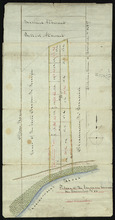
Plan of the Indian Reserve on Township No. 36
Description: Plan of part of Lot 36. The map shows a parcel of land, approximately 150 acres in size, identified as an Indian Reserve on the north side of the Hillsborough in Lot 36. The parcel is outlined in… more
Province: Prince Edward Island
Type: cadastral maps