Displaying 1 - 10 of 10
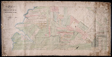
Plan of Township No. 31 in Prince Edward Island
Description: Plan of Lot 31 from H.J. Cundall, one of the Trustees of the Wm. Douse Estate (Death of Wm. Douse in 1864). Shows names of residents, acreages, and some land conveyance references, bodies of water… more
Province: Prince Edward Island
Type: cadastral maps
Plan of Township No. 31: compiled from the proprietors plans and Meacham's Atlas and from the…
Description: Plan of Lot 31 compiled from the Proprietors' plans and Meacham's Atlas and from the descriptions in leases and registered deeds, with additions and corrections from various surveys made… more
Province: Prince Edward Island
Type: cadastral maps
Date Created: 1917-12
Titles to Lot 31
Description: Plan of Lot 31 (No.84). Douse Estate. Shows names of some residents, some acreage, some land conveyance references, roads, and a nautical compass.
Province: Prince Edward Island
Type: cadastral maps

Plan of the Western Portion of Township No. 65: containing 5250 acres and belonging to Mrs. Lydia…
Description: Plan of the western portion of Lot 65 (No.173). Estate of Mrs Lydia Wright. Roads, leased land[?] and freehold land on the Estate of Mrs. Lydia Wright. Tenant names appear on the sub-lots, which are… more
Province: Prince Edward Island
Type: cadastral maps
Date Created: 1841
Plan of the division line between Lots 31 and 65, the commencement of which was set by the…
Description: Plan of the division line between Lots 31 and 65, the commencement of which was set by the Commissioners for establishing boundary lines. (No.1) The map shows lots, roads, and rivers.
Province: Prince Edward Island
Type: cadastral maps
Date Created: 1837-08-26
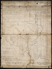
Lot 31: Southern portion
Description: Plan of the southern part of Lot 31, showing residents. In use 1819. From H.J. Cundall.
Province: Prince Edward Island
Type: cadastral maps

Plan of the Western Portion of Township No. 65: containing 5250 acres and belonging to Mrs. Lydia…
Description: Plan of the western portion of Lot 65 (No.173). Estate of Mrs Lydia Wright. Roads, leased land[?] and freehold land on the Estate of Mrs. Lydia Wright. Tenant names appear on the sub-lots, which are… more
Province: Prince Edward Island
Type: cadastral maps
Date Created: 1841
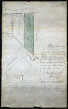
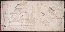
Plan shewing the situation of Malcolm Levingstone's Farm on Lot or Township No. 31, in…
Description: Plan of part of Lot 31. The map shows Malcolm Levingstone's farm of 56 ½ acres, coloured green, on the Baltic Road in Lot 31. The plan also shows the adjoining parcels of land and those on the… more
Province: Prince Edward Island
Type: cadastral maps
Date Created: 1865-12-26
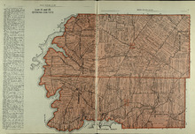
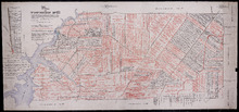
Lots 31 and 32: Queens County
Description: The map shows lots 31 and 32 in Queens county. Shown are rivers, landowners, acreage, roads, and railroads
Publisher: Cummins Map Co.
Province: Prince Edward Island
Type: cadastral maps
Date Issued (Source): 1927
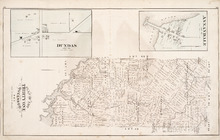
Plan of Lot Thirty One: Queens Co., P.E.I.
Description: The map shows lot 31 in Queens county. Shown are rivers, landowners and acreage, post offices, creeks, railroads and stations, roads, churches, a ferry, and school houses. Compass. Illustrated… more
Publisher: J. H. Meacham & company
Province: Prince Edward Island
Type: cadastral maps
Date Issued (Source): 1880