Displaying 1 - 11 of 11
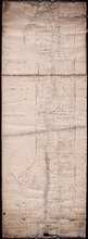
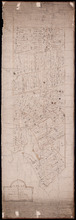
Plan of the East Moriety of Lot or Township No 29: part of the Estate of Lord Vicount Melville…
Description: Plan of the east moiety of Lot 29 (No.79). Part of the estate of Lord Viscount Melville. Shows names of residents, acreage, and a few land conveyance references, bodies of water such as the… more
Province: Prince Edward Island
Type: cadastral maps
Plan of the Moiety of Lot or Township No 29 of the Estate of Viscount elville situated in Prince…
Description: Plan of the east moiety of Lot 29 (No.2). Part of the estate of Lord Viscount Melville. The map shows lots, residents, roads, and bodies of water such as rivers.
Province: Prince Edward Island
Type: cadastral maps

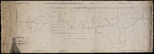
Plan of Township No. 29: embracing the Fane and Melville Estates – 1883
Description: Plan of Lot 29 (No.80). Fane and Melville Estates.
Province: Prince Edward Island
Type: cadastral maps
Date Created: 1883
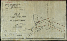
Plan of 117 ½ Acres of Land in the possession of James C. Wright together with several adjoining…
Description: Plan of part of Lot 29. 117½ acres of land in the possession of James C. Wright together with several adjoining tracts. Traced from original unsigned plan of Mr Clay by Thos. MacKinlay, June 17, 1882… more
Province: Prince Edward Island
Type: cadastral maps
Date Created: 1879-11-28
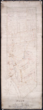
Plan of the Western Moriety of Township No. 29: The Estate of The honorable Lady Fane
Description: Plan of the western moiety of Lot 29 (No.78). The estate of the Hon. Lady Fane. Shows names of residents, acreage, and a few land conveyance references, bodies of water such as the Gulf of St.… more
Province: Prince Edward Island
Type: cadastral maps
A Plan of the Western Moriety of Township Number 29: The property of Colonel The Hon. H.S. Fane…
Description: Plan of the western moiety of Lot 29 (No.81). Property of Colonel the Hon. H.S. Fane. Shows names of residents, acreage, and roads. Signed by Owen Curtis, Land Surveyor.
Province: Prince Edward Island
Type: cadastral maps

Plan of Lot One: Prince Co., P.E.I.
Description: Map showing the northWestern tip of the island. It names the gulfs, rivers, ponds, landowners and acreage, roads, and railroads. A graphic compass.
Publisher: J. H. Meacham & company
Province: Prince Edward Island
Type: cadastral maps
Date Issued (Source): 1880

Victoria, Lot 29; Map of Lennox Island
Description: The page displays map of Victoria in Lot 29. Shown are roads and streets, a harbour, wharfs, landowners, post offices, buildings and school houses. Compass. The page also displays a map of Lennox… more
Publisher: J. H. Meacham & company
Province: Prince Edward Island
Type: cadastral maps
Date Issued (Source): 1880
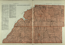
Lots 29 and 30: Queens County
Description: The map shows lots 29 and 30 in Queens county. Shown are roads, landowners, acreage, the Northumberland Strait, Westmoreland Harbour, and Sable River.
Publisher: Cummins Map Co.
Province: Prince Edward Island
Type: cadastral maps
Date Issued (Source): 1927

Plan of Lot Twenty Seven: Prince Co., P.E.I.
Description: The map shows lot 27 in Prince county. The map shows roads, railroads, crosses, ponds, rivers, bays, straits, coves, mills, post offices, and churhces. Graphic compass.
Publisher: J. H. Meacham & company
Province: Prince Edward Island
Type: cadastral maps
Date Issued (Source): 1880
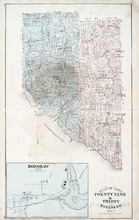
Plan of Lots Twenty Nine & Thirty: Queens Co., P.E.I.
Description: The map shows lots 29 (coloured in blue) and 30 (coloured in pink) in Queens county. The map shows straits, rivers, post offices, roads, landowners and acreage, and churches. Graphic compass.
Publisher: J. H. Meacham & company
Province: Prince Edward Island
Type: cadastral maps
Date Issued (Source): 1880