Displaying 1 - 8 of 8

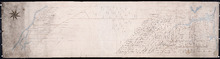
A Trace of West Coast, Prince Edward Island: from the Survey by Capt. Bayfield, R.N. furnished at…
Description: Plan of the West Coast of Prince Edward Island from the survey by Capt. Bayfield furnished at the request of a Committee of the House of Assembly, March 18, 1842. The coast line marked in red has… more
Province: Prince Edward Island
Type: cadastral maps
Date Created: 1842
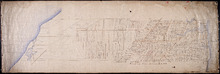
Plan of Lot 2
Description: The map shows Lot 2 divided into parcels of land. It provides the names of residents, their acreage amounts and some land conveyance references for most of the east end of the lot and for a small… more
Province: Prince Edward Island
Type: cadastral maps
Paln No. 1 of Railway Appropriation: from Alberton to Tignish
Description: Plan of Railway Appropriations from Alberton to Tignish. (Plan No.1). The map shows roads, resdients, acreage, lots, and foliage.
Province: Prince Edward Island
Type: cadastral maps
Date Created: 1873
Plan No. 2 of Railway Appopriation: From Alberton to Tignish
Description: Plan of Railway Appropriations from Alberton to Tignish. (Plan No.2). The map shows roads, lots, residents, acreage, and foliage.
Province: Prince Edward Island
Type: cadastral maps
Date Created: 1873
Plan of Lot 2 (No.7)
Description: Plan of Lot 2 (No.7). Cunard Estate. The map shows residents, and acreage, bodies of water, roads, and a division line.
Province: Prince Edward Island
Type: cadastral maps

Plan of Lot 2
Description: Plan of Lot 2 showing names of residents, acreage, and some land conveyance references, rivers, and roads.
Province: Prince Edward Island
Type: cadastral maps

Plan of Lot 2
Description: Plan of Lot 2. Plan referred to in the deed from Sir Edward, William and Laura Cunard to the Commissioner of Public Lands. Shows names of some residents, also gives some land conveyance references,… more
Province: Prince Edward Island
Type: cadastral maps
Date Created: 1866

Plan of Township No. 2: Compiled from the Proprietors Plans and partial surveys
Description: Plan of Lot 2 (No.5). Compiled from the Proprietors Plans and partial surveys by John Ball, Public Lands Department. Cunard Estate. Shows the names of residents, former occupants, and land conveyance… more
Province: Prince Edward Island
Type: cadastral maps
Date Created: 1885-10