Displaying 1 - 5 of 5
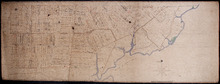
Plan of part of The Western Road.: W. Curtis
Description: (No. 46). The map shows a plan of the Western Road from St. Eleanor's to Lot 10. The road passes through Lots 10, 11, 12, 13, 14, 16 and 17. The map shows part of the Ellis River and other… more
Province: Prince Edward Island
Type: plans
Plan of Lot 14
Description: Plan of Lot 14 (No.40). Cunard Estate. Shows names of some residents, acreage, and a few land conveyance references. The map shows bodies of water such as Ellis (or Grand) River, and Cross River,… more
Province: Prince Edward Island
Type: cadastral maps
Date Created: 1847
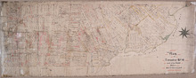
Plan of Township No 14: Compiled from the proprietors' plans and Meacham's Atlas, and…
Description: Plan of Lot 14 compiled from the proprietors' plans and Meacham's Atlas, and from the descriptions in leases and deeds, with additions and corrections from the reports of various surveys on… more
Province: Prince Edward Island
Type: cadastral maps
Date Created: 1914

Plan of Lot or Township No 14 : Situate in the Parish of Richmond, Prince County P.E.Island
Description: Plan of Lot 14 situate in the Parish of Richmond. One of the plans referred to in the deed from Sir Edward, William, and Laura Cunard to the Commissioner of Public Lands, July 13, 1866. Shows names… more
Province: Prince Edward Island
Type: cadastral maps
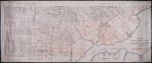
Plan of Township No 14: part of the Cunard Estate.
Description: Plan of Lot 14 (No.39). Part of Cunard Estate. Shows names of residents, acreage, and some land conveyance references. The map shows bodies of water, roads, post offices, a railroad station, and a… more
Province: Prince Edward Island
Type: cadastral maps