Displaying 1 - 7 of 7
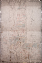
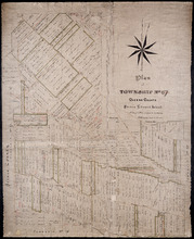
Plan of Township No 15: Taken from the survey of William Cutis (1826) wit alterations and…
Description: Plan of Lot 15 (No.42) taken from the survey of William Curtis (1826) with alterations and corrections from surveys made in 1849 and 1851 by Geo. Wright. Color code shows Crown Lands and lands… more
Province: Prince Edward Island
Type: cadastral maps
Date Created: 1851
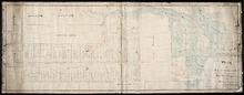
Plan of Lot or Township No 59: Two Thirds being the property of The Messrs Montgimeries being 13,…
Description: Plan of Lot 59 (No.157). Two thirds being the property of the Messrs. Montgomeries being 13,064 acres. One third, the property of Earl Selkirk. Plan copied by Jas. J. Bevan. Date of plan: April 1848… more
Province: Prince Edward Island
Type: cadastral maps

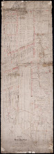
Township No. Fiftyfour. St. Georges Parish. Kings County. Prince Edward Island.: Chiefly from…
Description: Plan of Lot 54 (No.145). Shows names of residents, acreage, and some land conveyance references. Copied by H.J. Cundall. Certified plan. The map also shows bodies of water such as rivers (Cardigan),… more
Province: Prince Edward Island
Type: cadastral maps
Plan of Township No. 54: Chiefly from Surveys by Geo. Wright and Rodk. Campbell copied By Owen…
Description: Plan of Lot 54, chiefly from surveys by Geo. Wright and Rod'k Campbell. Copied by Owen Curtis, 1877. Shows names of residents, acreage, and land conveyance references, roads, bodies of water,… more
Province: Prince Edward Island
Type: cadastral maps
Date Created: 1877
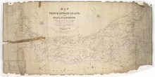
Map of Prince Edward Island, in the Gulf of St. Lawrence,: Compiling the latest Topographical…
Description: Map of Prince Edward Island by George Wright, Surveyor General, 1852. The Sea Coast, Rivers, Vc. being laid down from the Survey recently completed by Captain H. W. Bayfield R.N. The map shows mail… more
Province: Prince Edward Island
Type: cadastral maps
Date Created: 1852
Plan of Township No. 67 Queens County Prince Edward Island: A Copy of a Plan compiled by Geo.…
Description: A copy of a plan of Lot 67 compiled by Geo. Wright, 1858, slightly altered to agree with Meacham's Atlas (No.179). Shows names of residents and acreage, lots, streets and roads, and post offices. more
Province: Prince Edward Island
Type: cadastral maps
Date Created: 1885-07
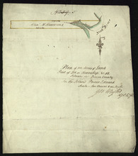
Plan of 100 Acres of Land Part of Lot or Township No. 32.: Situate in Queens County In the Island…
Description: Plan of part of Lot 32 (No.5). 100 acres of land, the property of Alexr. McKenzie. The plan shows 100 acres of land belonging to Alexander McKenzie, outlined in yellow, on the west side of the York (… more
Province: Prince Edward Island
Type: cadastral maps