Displaying 1 - 4 of 4

Plan of Lot Thirty Seven: Queens Co., P.E.I.
Description: Map of Lot 37 and part of Lot 38. Map is from Meacham's 1880 PEI Historical Atlas. A few land conveyance references have been added in red ink. The map shows bodies of water such as rivers,… more
Province: Prince Edward Island
Type: cadastral maps
Date Created: 1880
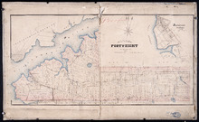
Map of Lot Forty-Eight: J.H. Meachams and Co. Atlas
Description: Map of Lot 48. Draft for Meacham's Atlas. Also includes inset map of Southport or Stratford (scale: 6 chains/inch). Shows the Charlottetown Royalty, bodies of water such as rivers, and lakes,… more
Province: Prince Edward Island
Type: cadastral maps

Illustrated historical atlas of the province of Prince Edward Island: From surveys made under the…
Description: Published in 1880 by the J. H. Meacham Company, the Illustrated Historical Atlas of the Province of Prince Edward Island contains maps of each Lot on the Island, maps of Charlottetown and various… more
Publisher: J. H. Meacham & company
Type: historical atlases, pictorial maps
Date Issued: 1880
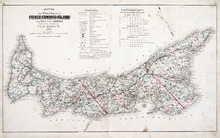
Map of the Province of Prince Edward Island: in the Gulf of St. Lawrence
Description: The map shows the province of Prince Edward Island. Shown are tables of Explanations and Electorial Districts, a compass and the county lines are marked in red. Shown are gulfs, straits, bays, reefs… more
Publisher: J. H. Meacham & company
Province: Prince Edward Island
Type: cadastral maps
Date Created: 1880
Date Issued (Source): 1880