Displaying 271 - 297 of 297
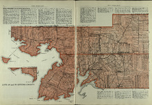
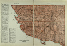
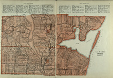
Lots 33 and 34 : Queens County
Description: The map shows lots 33 and 34 in Queens county. Shown are the Gulf of St. Lawrence, Cove Head and Rustico Bay, Hillsborough River, landowners, acreage, roads, railroads, Royalty Junction and Suffolk… more
Publisher: Cummins Map Co.
Province: Prince Edward Island
Type: cadastral maps
Date Issued (Source): 1927
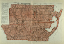
Lot 65: Queens County
Description: The map shows Lot 65 in Queens County. Shown are the Northumberland Strait, Hillsborough Bay, Elliott River, roads, landowners, acreage, and towns.
Publisher: Cummins Map Co.
Province: Prince Edward Island
Type: cadastral maps
Date Issued (Source): 1927
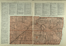
Lot 48: Queens County
Description: The map shows lot 48 in Queens county. Shown are Hillsborough River, Fullerton Creek, railroads, roads, landowners, and acreage.
Publisher: Cummins Map Co.
Province: Prince Edward Island
Type: cadastral maps
Date Issued (Source): 1927
Lots 49 and 50: Queens County
Description: The map shows lots 49 and 50 in Queens county. Shown are bays, Governor Island, points, rivers, roads, railroads, landowners, and acreage.
Publisher: Cummins Map Co.
Province: Prince Edward Island
Type: cadastral maps
Date Issued (Source): 1927
Rural Directory - Lots 49 and 50, Queens County
Description: A directory listing of residents of lots 49 and 50.
Publisher: Cummins Map Co.
Province: Prince Edward Island
Type: text
Date Issued (Source): 1927
Rural Directory - Lots 57 and 58, Queens County
Description: A directory listing of residents of lots 57 and 58.
Publisher: Cummins Map Co.
Province: Prince Edward Island
Type: text
Date Issued (Source): 1927
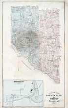
Plan of Lots Twenty Nine & Thirty: Queens Co., P.E.I.
Description: The map shows lots 29 (coloured in blue) and 30 (coloured in pink) in Queens county. The map shows straits, rivers, post offices, roads, landowners and acreage, and churches. Graphic compass.
Publisher: J. H. Meacham & company
Province: Prince Edward Island
Type: cadastral maps
Date Issued (Source): 1880
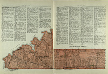
Lots 57 and 58: Queens County
Description: The map shows lots 57 and 58 in Queens county. Shown are Pinette Harbour, Northumberland Strait, Orwell Bay, rivers, roads, railroads, landowners,and acreage.
Publisher: Cummins Map Co.
Province: Prince Edward Island
Type: cadastral maps
Date Issued (Source): 1927
Lots 60 and 62: Queens County
Description: The map shows lots 60 and 62 in Queens county. Shown are the Northumberland Strait, roads, railroads, harbour, points, landowners, and acreage.
Publisher: Cummins Map Co.
Province: Prince Edward Island
Type: cadastral maps
Date Issued (Source): 1927
Plan of Lot Thirty One: Queens Co., P.E.I.
Description: The map shows lot 31 in Queens county. Shown are rivers, landowners and acreage, post offices, creeks, railroads and stations, roads, churches, a ferry, and school houses. Compass. Illustrated… more
Publisher: J. H. Meacham & company
Province: Prince Edward Island
Type: cadastral maps
Date Issued (Source): 1880
Rural Directory - Lots 60 and 62, Queens County
Description: A directory listing of residents of lots 60 and 62.
Publisher: Cummins Map Co.
Province: Prince Edward Island
Type: text
Date Issued (Source): 1927
Rural Directory - Lots 35 and 36, Queens County
Description: A directory listing of residents of lots 35 and 36.
Publisher: Cummins Map Co.
Province: Prince Edward Island
Type: text
Date Issued (Source): 1927
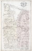
Lots 35 and 36: Queens County
Description: The map shows lots 35 and 36 in Queens County. Shown are Hillsborough River, Tracadie Bay, Gulf of St. Lawrence. Mill Cove, landowners, acreage, raods, and railroads.
Publisher: Cummins Map Co.
Province: Prince Edward Island
Type: cadastral maps
Date Issued (Source): 1927
Lot 37, Queens County: Lot 38 Kings County
Description: The map shows lot 37 in Queens county and lot 38 in Kings county. Shown are the Gulf of St. Lawrence, Savage Harbour, landowners, acreage, roads, railroads, and rivers.
Publisher: Cummins Map Co.
Province: Prince Edward Island
Type: cadastral maps
Date Issued (Source): 1927
Plan of Lot Thirty Five & Thirty Six: Queens Co., P.E.I.
Description: The map shows lots 35 & 36 in Queens county. Shown are gulfs, bays, sand, coves, wharfs, rivers, ponds, creeks, fishing houses, roads, landowners and acreage, post offices, school houses,… more
Publisher: J. H. Meacham & company
Province: Prince Edward Island
Type: cadastral maps
Date Issued (Source): 1880
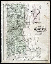
Plan of Lot Thirty Two: Queens Co., P.E.I.
Description: The map shows lot 32 in Queens county. Shown are roads, landowners and acreage, railroad and station, post offices, rivers, churches, and coves. Compass.
Publisher: J. H. Meacham & company
Province: Prince Edward Island
Type: cadastral maps
Date Issued (Source): 1880

Plan of Lot Thirty Seven : Plan of Lot Thirty Eight: Queens Co., P.E.I.. Kings Co., P.E.I.
Description: The map shows lot 37 (coloured in pink) in Queens county, and lot 38 (coloured in blue) in Kings county. Shown are roads, railroads, landowners and acreage, rivers, ponds, harbours, gulfs, creeks,… more
Publisher: J. H. Meacham & company
Province: Prince Edward Island
Type: cadastral maps
Date Issued (Source): 1880
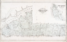
Plan of Lot Fourty Eight: Queens Co., P.E.I.
Description: The map showing lots 48 in Queens county. Shown are the commissioners line, rivers, coves, marsh, creeks, ponds, lakes, roads, landowners and acreage, asylum, hospital, and post offices. Graphic… more
Publisher: J. H. Meacham & company
Province: Prince Edward Island
Type: cadastral maps
Date Issued (Source): 1880
Plan of Lots 49 & 50: Queens Co., P.E.I.
Description: The map shows lot 49 & 50 in Queens County. Shown are roads, landowners and acreage, lakes, bays, coves, wharfs, post offices, churches, and schools. Graphic compass
Publisher: J. H. Meacham & company
Province: Prince Edward Island
Type: cadastral maps
Date Issued (Source): 1880
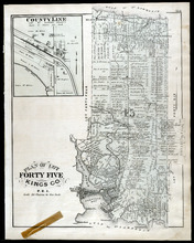
Plan of Lot Fourty Five: Kings Co., P.E.I.
Description: The map shows Lot 45 in Kings county. Shown are the gulf, bay, rivers, coves, post offices, cross, mills, roads, railroad, landowners and acreage, churches, hospital, harbour, and sand. Compass.
Publisher: J. H. Meacham & company
Province: Prince Edward Island
Type: cadastral maps
Date Issued (Source): 1880
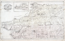
Plan of Lots Fifty Seven & Fifty Eight: Queens Co., P.E.I.
Description: The map shows lots 57 & 58 in Queens county. Includes an inset map of Prim Island / Point Prim. Shown are roads, landowners and acreage, crosses, rivers, ponds, creeks, bays, coves, sand, wharfs… more
Publisher: J. H. Meacham & company
Province: Prince Edward Island
Type: cadastral maps
Date Issued (Source): 1880
Plan of Lot Sixty & Sixty Two: Queens Co., P.E.I.
Description: The map shows lots 60 & 62 in Queens county. Shown are roads, landowners and acreage, rivers, straits, ponds, bays, creeks, sand, post offices, mills, churches, and school houses. Graphic compass.
Publisher: J. H. Meacham & company
Province: Prince Edward Island
Type: cadastral maps
Date Issued (Source): 1880
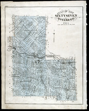
Plan of Lot Sixty Seven: Queens Co., P.E.I.
Description: The map shows Lot 67 in Queens county. Shown are roads, landowners and acreage, railroads and stations, post offices, church, and school houses. Compass.
Publisher: J. H. Meacham & company
Province: Prince Edward Island
Type: cadastral maps
Date Issued (Source): 1880
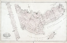
Plan of Lot 65 : Queens Co., P.E.I.
Description: The map shows Lot 65 in Queens county. Shown are roads, landowners and acreage, creeks, rivers, straits, marshes, brooks, coves, sand, reef, fishing stage, wharfs, post offices, mills, churches,… more
Publisher: J. H. Meacham & company
Province: Prince Edward Island
Type: cadastral maps
Date Issued (Source): 1880
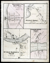
Port Selkirk Farm or Brush Wharf, Stanley Bridge: Murray Harbour South, and Vernon River Bridge
Description: The map shows Port Selkirk Farm or Brush Wharf lot 57 in Queens county. Shown are a river, wharf, road and street, landowners, and measurements. Compass.
Publisher: J. H. Meacham & company
Province: Prince Edward Island
Type: cadastral maps
Date Issued (Source): 1880
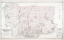
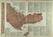
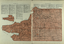
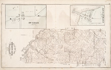
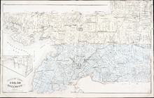
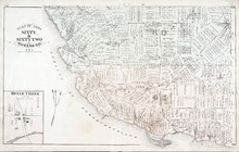
Plan of Charlottetown Royalty: Queens Co., P.E.I.
Description: The map shows the city of Charlottetown and a plan for lots. Shown are rivers, creeks, roads, railroad and stations, landowners and acreage, mills, park, bridge, college, farms, asylums, and a… more
Publisher: J. H. Meacham & company
Province: Prince Edward Island
Type: cadastral maps
Date Issued (Source): 1880

Montague Bridge Lots 59 & 52: Kings Co., P.E.I.
Description: The map shows lots 59 & 52 in Montague Bridge, Kings county. Shown are rivers, wharfs, shipyards, roads, landowners and acreage, halls, churches, buildings and businesses. Compass.
Publisher: J. H. Meacham & company
Province: Prince Edward Island
Type: cadastral maps
Date Issued (Source): 1880