Displaying 1 - 5 of 5

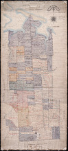
Plan of Township No. 67, and its environs.: Compiled from Surveys by Geo. Wright; H.J. Cundall;…
Description: Plan of Lot 67 and its environs. Compiled from surveys by Geo. Wright, H.J. Cundall, Joseph Ball, and Owen Curtis. Drawn by Thomas MacKinlay. Shows names of some residents, roads, railroads, bodies… more
Province: Prince Edward Island
Type: cadastral maps
Date Created: 1877-08-01
Plan of Township No. 33 In Prince Edward Island. Part of the Estate of the late John Hodges Winslow…
Description: Plan of Lot 33 (No.88). Part of the estate of the late John Hodges Winslow. Copied from the Original Plan by Thos. MacKinlay, April 23, 1847. Shows names of residents, acreage, and land conveyance… more
Province: Prince Edward Island
Type: cadastral maps
Date Created: 1847-04-23

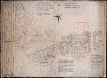
Plan of Township No. 30 belonging to R. Bruce Stewart, Drawn by Robt. Stewart 1861 from surveys…
Description: The map shows Lot 30 divided into numbered sub-lots. There are nine different series of sub-lot numbers which are colour-coded according to the map legend. The different colours represent Line Road,… more
Province: Prince Edward Island
Type: cadastral maps
Date Created: 1861
Plan of 1390 Acres of Land part of Township No. 65: The Property of the Honble. Samuel Cunard.…
Description: Plan of Lot 65 (No.178). Shows names of residents, acreage, and land conveyance references. Color code indicates freehold land and the estates of the Wrights, Cunard and Cumberland. Shows bodies of… more
Province: Prince Edward Island
Type: cadastral maps
A Plan of the Western Moriety of Township Number 29: The property of Colonel The Hon. H.S. Fane…
Description: Plan of the western moiety of Lot 29 (No.81). Property of Colonel the Hon. H.S. Fane. Shows names of residents, acreage, and roads. Signed by Owen Curtis, Land Surveyor.
Province: Prince Edward Island
Type: cadastral maps