Displaying 136 - 162 of 201
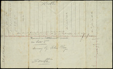
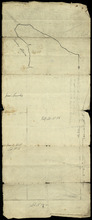
Reserved or Settlement road on Lot 5
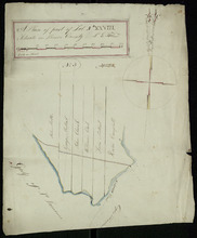
Description: Plan of part of Lot 5. The farms on the north side of the Reserved or Settlement Road. The map shows 20 parcels of land on the north side of the Reserve or Settlement Road in the western portion of… more
Province: Prince Edward Island
Type: cadastral maps
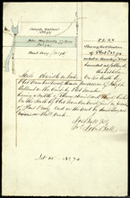
Plan Shewing the Situation of Plot No. 94 on Lot or Township No. 15
Description: Plan of part of Lot 15 (No.74). Shows the situation of Plot No.94, the property of John MacInally. 77 acres. MacInally's plot is shaded green. Map also shows Joseph Gallant's Plot No. 93 to… more
Province: Prince Edward Island
Type: cadastral maps
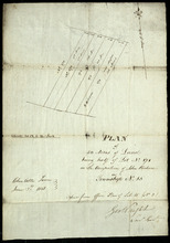
Plan of 50 Acres of Land being half of Lot No. 171 in the Occupation of John Rechore in Township No…
Description: Plan of part of Lot 15. 50 acres of land, part of 171 in the occupation of John Rechore. Also shows (sub) lots 170, 172, 173 and 174. Copied from office plan of Lot 15. (No.3)
Province: Prince Edward Island
Type: cadastral maps
Date Created: 1851-06-03
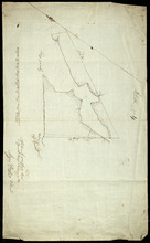
Plan of 500 Acres Land in Egmont Bay 7th February 1814
Description: The map shows 500 acres of land around the mouth of the Haldimand River in Egmont Bay, northeast of Cape Egmont. Plan of part of Lot 15 (No.4).
Province: Prince Edward Island
Date Created: 1814-02-07
Half Lot No. 18
Description: Plan of the eastern half of Lot 18 (No.3). Mainly outline.
Province: Prince Edward Island
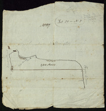
Part of Lot 18
Description: Plan of part of Lot 18 (No.6). Two Ramsay properties, each 100 acres in size, along Oyster Cove in Lot 18. Sandy and/or marshy areas shown with stippling/shading. North arrow.
Province: Prince Edward Island
Type: cadastral maps
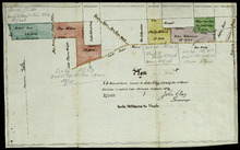
Part of Lot 25
Description: Plan of part of Lot 25 (No.4). Thompson-Taylor land. This item consists of 2 maps——on separate pieces of paper——of the parcels of land belonging to John Thompson (200 acres) and William Taylor (320… more
Province: Prince Edward Island
Type: cadastral maps
Date Created: 1809-11-20
Plan of 75 Acres of land leased to John Clay, showing the different divisions in which it was…
Description: Plan of part of Lot 26. The plan shows 75 acres of land in the western part of Lot 26 leased to John Clay and then later divided and conveyed to other individuals. The plan shows names of residents… more
Province: Prince Edward Island
Type: cadastral maps
Date Created: 1878-08-05
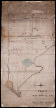
Lot 28 -- No. 2
Description: Plan of part of Lot 28 (No.2). The map shows 200 acres of land along the Northumberland Strait between Crapuad Creek and the Tryon River in Lot 28. Areas that appear to be marshes are indicated with… more
Province: Prince Edward Island
A Plan of part of Lot No. XXVIII. Situate in Prince County P. E. Island
Description: Plan of part of Lot 28 (No.3). The map shows 6 parcels of land with residents' names at Cape Traverse in Lot 28. The Northumberland Strait (which is labelled as the Gulf of St. Lawrence) is… more
Province: Prince Edward Island
Type: cadastral maps
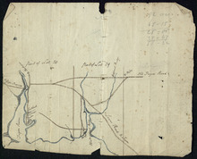
Part of Lots 28 and 29
Description: Plan of part of Lots 28 and 29 (No.9). The maps shows the area around the Tryon and Westmoreland (or Crapaud) rivers in Lots 28 and 29. It gives the names of a few residents and shows several roads,… more
Province: Prince Edward Island
Tracing of Plan of A part of the South Moiety of Lot or Township No. 26 in Prince County in the…
Description: Plan of part of the south moiety of Lot 26, including the property of A. E. C. Holland. Plan drawn by John Clay. The map shows part of the southern half of Lot 26 divided into parcels of land with… more
Province: Prince Edward Island
Type: cadastral maps
Date Created: 1876-05-12
Plan of Lot 27 Prince County: The Property of James P.
Description: Plan of the northern part of Lot 27 (No.72). Pope Estate. Shows names of residents and acreage, the Northumberland Strait, mill pond, and roads. Plan referred to in the Deed from Pope to the… more
Province: Prince Edward Island
Type: cadastral maps
Plan of Part of the Estate of R.B. Stewart Esq. Situate on Lot or Township No. 27 shewing the…
Description: Plan of part of Lot 27. Estate of R.B. Stewart. Shows names of residents, acreage, and a few land conveyance references, roads, and the sea shore.
Province: Prince Edward Island
Type: cadastral maps
Date Created: 1848-03-24
A Plan of Part of Lot No. XXVII Situat in P.E.I. the Property of J. Cambridge Esq. from an Actual…
Description: Plan of part of Lot 27 (No.74). The property of J. Cambridge. Shows names of residents and acreage, Carlton Cove and a compass. Plan is one of those referred to in the Deed from Sir Edward, William… more
Province: Prince Edward Island
Type: cadastral maps
Date Created: 1828-08
Copy of Plan of part of Lot 27 Prince County P.E.I. Purchased from Hon. J. C. Pope
Description: Copy of plan of part of Lot 27 purchased from Hon. J.C. Pope. The plan is referred to in the Deed from James Colledge Pope and his wife to the Commissioner of Public Lands, July 13, 1868. The map… more
Province: Prince Edward Island
Type: cadastral maps
Date Created: 1868
Plan of Part Township No. 28: The property of Henry Palmer Esquire
Description: Plan of part of Lot 28 (No.75). The property of Henry Palmer. Shows names of residents, acreage , and land conveyance references, bodies of water such as marshes, straits, and rivers, roads,… more
Province: Prince Edward Island
Type: cadastral maps

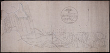
Alberton, Prince Edward Island: Population 1500. Hand Engine. 400' Hose. Water Supply: Brook…
Description: This is a fire insurance plan of the town of Alberton concentrating on two blocks of Main Street from Church Street to Argyle Street. A key plan in the lower left corner provides context. The map was… more
Publisher: Chas. E. Goad, Civil Engineer
Province: Prince Edward Island
Type: fire insurance maps
Date Created: 1888-10
Date Modified: 1910-10
Date Issued (Source): 1888

Map of Prince Edward Island in the Gulf of St. Lawrence: for McGregor's British America
Publisher: Ballantyne and Company
Province: Prince Edward Island
Type: cadastral maps, topographic maps
Date Created: 1832
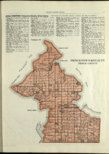
Princetown Royalty: Prince County
Description: The map shows Princetown Royalty in Prince County. Shown are rivers, bays, roads, landowners, acreage, and towns. Atlas of Province of Prince Edward Island, Canada and the World
Publisher: Cummins Map Co.
Province: Prince Edward Island
Type: cadastral maps
Date Issued (Source): 1927
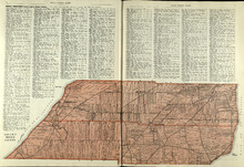
Lot No. 1 : Prince County
Description: The map shows Lot 1 in Prince county. Shown are the Gulf of St. Lawrence, ponds, rivers, creeks, landowners, acreage, roads and a railroad.
Publisher: Cummins Map Co.
Province: Prince Edward Island
Date Issued (Source): 1927
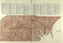
Lots 2 & 3 : Prince County
Description: The map shows lots 2 & 3 in Prince county. Shown are the Gulf of St. Lawrence, capes, ponds, landowners, acreage, rivers, and roads.
Publisher: Cummins Map Co.
Province: Prince Edward Island
Type: cadastral maps
Date Issued (Source): 1927
Lots 4 : Prince county
Description: The map shows Lots 4
Publisher: Cummins Map Co.
Province: Prince Edward Island
Type: cadastral maps
Date Issued (Source): 1927
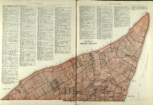
Rural Directory - Lots 4 - 6, Prince County
Description: A directory listing of residents of lots 4, 5, and 6.
Publisher: Cummins Map Co.
Province: Prince Edward Island
Type: text
Date Issued (Source): 1927

Plan of Lot One: Prince Co., P.E.I.
Description: Map showing the northWestern tip of the island. It names the gulfs, rivers, ponds, landowners and acreage, roads, and railroads. A graphic compass.
Publisher: J. H. Meacham & company
Province: Prince Edward Island
Type: cadastral maps
Date Issued (Source): 1880
Lot 6: Prince County
Description: The map shows Lot 6 in Prince county. Shown are roads, landowners, acreage, railroad, rivers, and Oyster creek
Publisher: Cummins Map Co.
Province: Prince Edward Island
Date Issued (Source): 1927