Displaying 487 - 513 of 773
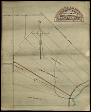
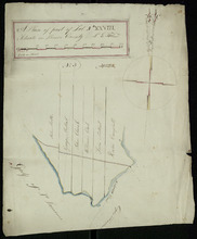
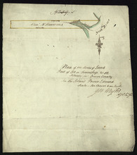
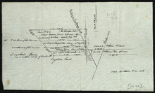
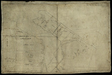
Plan of Proposed Road on A. Dickerson's Farm Township No. 23: Surveyed by John P. Nicholson P…
Description: Plan of proposed road on A. Dickerson's Farm on Lot 23. (No.53). The plan shows a proposed new road, coloured orange, through Arthur Dickerson's farm between Rennie Road and St. Mary's… more
Province: Prince Edward Island
Type: engineering maps
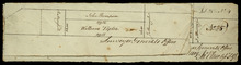
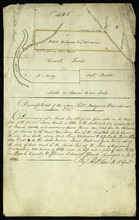
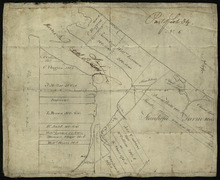
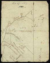
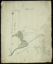
Part of Lot 25
Description: Plan of part of Lot 25 (No.4). Thompson-Taylor land. This item consists of 2 maps——on separate pieces of paper——of the parcels of land belonging to John Thompson (200 acres) and William Taylor (320… more
Province: Prince Edward Island
Type: cadastral maps
Date Created: 1809-11-20
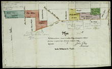
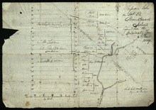
Plan of 75 Acres of land leased to John Clay, showing the different divisions in which it was…
Description: Plan of part of Lot 26. The plan shows 75 acres of land in the western part of Lot 26 leased to John Clay and then later divided and conveyed to other individuals. The plan shows names of residents… more
Province: Prince Edward Island
Type: cadastral maps
Date Created: 1878-08-05
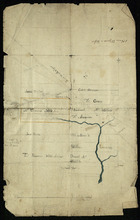
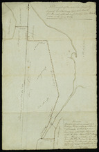
Lot 28 -- No. 2
Description: Plan of part of Lot 28 (No.2). The map shows 200 acres of land along the Northumberland Strait between Crapuad Creek and the Tryon River in Lot 28. Areas that appear to be marshes are indicated with… more
Province: Prince Edward Island
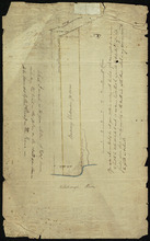
A Plan of part of Lot No. XXVIII. Situate in Prince County P. E. Island
Description: Plan of part of Lot 28 (No.3). The map shows 6 parcels of land with residents' names at Cape Traverse in Lot 28. The Northumberland Strait (which is labelled as the Gulf of St. Lawrence) is… more
Province: Prince Edward Island
Type: cadastral maps
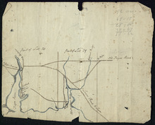
Part of Lots 28 and 29
Description: Plan of part of Lots 28 and 29 (No.9). The maps shows the area around the Tryon and Westmoreland (or Crapaud) rivers in Lots 28 and 29. It gives the names of a few residents and shows several roads,… more
Province: Prince Edward Island
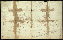
Entrance to the Croppo River
Description: Plan of part of Lot 29 (No.4). Entrance to Croppo River. Shows soundings at Crapaud Harbour. The map shows the harbour and entrance to the Crapaud (or Westmoreland) River. Soundings appear to be… more
Province: Prince Edward Island
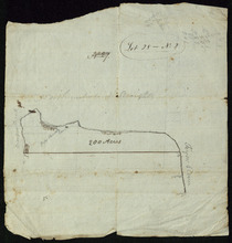
Plan of 117 ½ Acres of Land in the possession of James C. Wright together with several adjoining…
Description: Plan of part of Lot 29. 117½ acres of land in the possession of James C. Wright together with several adjoining tracts. Traced from original unsigned plan of Mr Clay by Thos. MacKinlay, June 17, 1882… more
Province: Prince Edward Island
Type: cadastral maps
Date Created: 1879-11-28
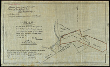
Plan of 100 Acres of Land Part of Lot or Township No. 32.: Situate in Queens County In the Island…
Description: Plan of part of Lot 32 (No.5). 100 acres of land, the property of Alexr. McKenzie. The plan shows 100 acres of land belonging to Alexander McKenzie, outlined in yellow, on the west side of the York (… more
Province: Prince Edward Island
Type: cadastral maps
Part of Lot 32: The property of Robert Hodgson
Description: Plan of part of Lot 32 (No.6). The map shows 200 acres of land, outlined in yellow, belonging to Robert Hodgson on the west side of the Prince Town Road in Lot 32. It shows some neighbouring parcels… more
Province: Prince Edward Island
Type: cadastral maps
Date Created: 1810
Refugee Lots on Lot 32 Prince Edward Island: Copied from the Original Plan
Description: Plan of Refugee Lots on Lot 32. Copied from the original. The map shows a northern portion of Lot 32 divided into numbered refugee lots, each 100 acres in size. It gives the names of some residents,… more
Province: Prince Edward Island
Type: cadastral maps
Date Created: 1809
Part of Lot 32: Refugee Lots
Description: Plan of part of Lot 32 (No.4). Refugee Lots. The map shows a northern part of Lot 32 that was divided into refugee lots. It gives the names of residents and acreage amounts for some. The map shows a… more
Province: Prince Edward Island
Type: cadastral maps
Part of Lot 32
Description: Plan of part of Lot 32. North Milton area. The map shows the area around the intersection of the New Glasgow and Rustico roads in the northern part of Lot 32. The land is divided into parcels with… more
Province: Prince Edward Island
Type: cadastral maps
Part of Lot 33: Area around Rustico Bay
Description: Plan of part of Lot 33. Area around Rustico Bay. The map shows the area around Rustico Bay in the northwest part of Lot 33. It shows the land divided into parcels with names of some residents and… more
Province: Prince Edward Island
Type: cadastral maps
Parts of Lot 33: Two maps showing the northern extremities of the east and west boundaries of Lot 33
Description: Plans of two parts of Lot 33 (No.4): McMillan's Point; Grand Pere Point. This item consists of 2 maps on one sheet--one each on the front and back. Side One shows McMillan Point on Covehead Bay… more
Province: Prince Edward Island
Type: boundary maps
Part of Lot 34
Description: Plan of part of Lot 34 (No.5). Shows properties of John Millar, L. Brown, Neil Shaw, Murdock McCloud, and John Crabtree. The map shows the northwestern portion of Lot 34 divided into parcels of land… more
Province: Prince Edward Island
Type: cadastral maps
Part of Lot 34
Description: Plan of part of Lot 34 (No.3). Area around Covehead Bay. The map shows the northwestern portion of Lot 34, divided into parcels of land with the names of residents and/or proprietors and their… more
Province: Prince Edward Island
Type: cadastral maps
Part of Lot 34
Description: Plan of part of Lot 34 (No.6). Area around Covehead Bay. The map shows the northwestern portion of Lot 34 divided into parcels of land with the names of residents and/or proprietors and their acreage… more
Province: Prince Edward Island
Type: cadastral maps
A Draugth of the new road opened by order of his Excellency Governor Smith, for the west settlement…
Description: Plan of part of Lot 34 (No.41). This plan shows a new road in the Covehead area in the northwest corner of Lot 34. It describes the land surrounding the road with labels noting swamp or hardwood… more
Province: Prince Edward Island
Type: engineering maps
Date Created: 1824
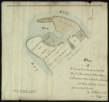
Plan of Mrs. Vickersons Land
Description: Plan of part of Lot 34 (No. 4). 74 acres of land. The map shows Barbarey Vickerson's 74-acre parcel of land on the north side of the Hillsborough River in Lot 34. The plan shows roads, including… more
Province: Prince Edward Island
Type: cadastral maps
Date Created: 1809-10-12
Plan of A tract of Land the property the Messrs. Macmillans & Peter Higgins on Township No. 34…
Description: Plan of part of Lot 34 (No. 182). The map shows a parcel of land 111 acres in size belonging to Angus MacMillan, Peter Higgins and Alexander MacMillan near the entrance to Covehead Harbour and what… more
Province: Prince Edward Island
Type: cadastral maps
Date Created: 1854
Plan of the Indian Reserve on Township No. 36
Description: Plan of part of Lot 36. The map shows a parcel of land, approximately 150 acres in size, identified as an Indian Reserve on the north side of the Hillsborough in Lot 36. The parcel is outlined in… more
Province: Prince Edward Island
Type: cadastral maps
Plan Shewing the front of Lots No.s 36 & 37
Description: Office copy from the original survey of Prince Edward Island showing the front of Lots 36 and 37. (No.3) The map shows the northern-most portions of Lots 36 and 37 on the north shore, east of… more
Province: Prince Edward Island
Type: boundary maps
Date Created: 1840-09-11
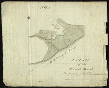
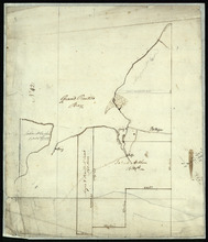
A Plan of the French Marsh: the property of Wm. Townshend. Esqr.
Description: Plan of part of Lot 37 (No.9). The French Marsh. The map shows a marsh area belonging to William Townshend on the north side of the Hillsborough River in Lot 37. Marsh area is shaded and coloured… more
Province: Prince Edward Island
Type: cadastral maps, topographic maps
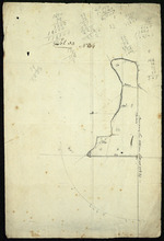
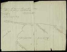
Lot 37 - No. 7
Description: Plan of part of Lot 37 (No. 7). Area south of the Hillsborough River. The maps shows a small area on the south side of the Hillsborough River in Lot 37 adjacent to the boundary with Lot 38. It shows… more
Province: Prince Edward Island
Type: cadastral maps
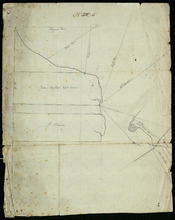
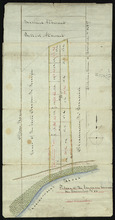
Plan of 150 Acres of Land Part of Lot No. 37.
Description: Plan of part of Lot 37 (No. 8). 150 acres of land, the property of John Stowe. The map shows a parcel of land, approximately 150 acres in size, outlined in yellow, on the north side of the… more
Province: Prince Edward Island
Type: cadastral maps