Displaying 271 - 297 of 773

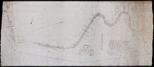
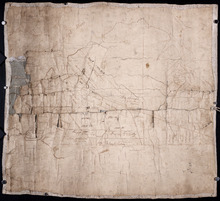
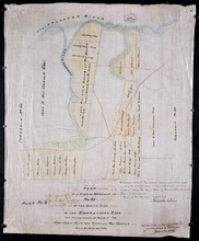
Tracing of the right of way for the Prince Edward Island Railway into Georgetown.
Description: Tracing of the right of way for the Prince Edward Island Railway into Georgetown.
Province: Prince Edward Island
Type: cadastral maps
This Plan shewing the lands appropriated by the Railway Commisioners is filed with the Office of…
Description: Prince Edward Island Railway. Plan shows land appropriated by the Railway Commissioners on Lot 45. (No.235C). The map shows residents, acreage, roads, and a church.
Province: Prince Edward Island
Type: cadastral maps

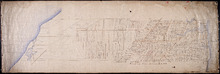
Plan of Prince Edward Island showing the names of the Proprietors
Description: Plan of Prince Edward Island showing the names of the Proprietors, their acreage, and the number of settlers on their property. The map shows Prince Edward Island divided into the 67 lots established… more
Province: Prince Edward Island
Type: topographic maps

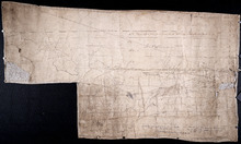
Plan of Part of the Railway Line on Lots No. 16 and 17
Description: Plan of part of the Railway Line on Lots 16 and 17. Appropriations from Lot 16 to the French purchase. The map shows roads, lots, residents, and acreage.
Province: Prince Edward Island
Type: cadastral maps
Date Created: 1872-04-29

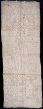
Plan of Part of the Railway Line on Lot No. 17: Shewing the Stations Grounds at Summerside.
Description: Plan of part of the Railway Line on Lot 17 showing the Station Grounds at Summerside (No.2). Former location of the appropriations from Linkletter Road into Summerside. The map shows roads, lots,… more
Province: Prince Edward Island
Type: cadastral maps
Date Created: 1872-04-29
Paln No. 1 of Railway Appropriation: from Alberton to Tignish
Description: Plan of Railway Appropriations from Alberton to Tignish. (Plan No.1). The map shows roads, resdients, acreage, lots, and foliage.
Province: Prince Edward Island
Type: cadastral maps
Date Created: 1873
Plan No. 2 of Railway Appopriation: From Alberton to Tignish
Description: Plan of Railway Appropriations from Alberton to Tignish. (Plan No.2). The map shows roads, lots, residents, acreage, and foliage.
Province: Prince Edward Island
Type: cadastral maps
Date Created: 1873

Plan of Alberton: Surveyed by John Ball, Land Surveyor
Description: Plan of part of Alberton, Lot 4. Shows names of residents and land conveyance references, bodies of water such as bays, and creeks, and roads.
Province: Prince Edward Island
Type: cadastral maps
Date Created: 1871-08
Plan of Township No. 3: Copied from Mr. Andersons Plan 1847 by Geo. Wright
Description: Plan of Lot 3 showing the Township divided into 21 lots. Plan copied by Geo. Wright. The map shows names of residents, acreage, roads, rivers, and capes.
Province: Prince Edward Island
Type: cadastral maps
Date Created: 1847
Plan of Lot 2 (No.7)
Description: Plan of Lot 2 (No.7). Cunard Estate. The map shows residents, and acreage, bodies of water, roads, and a division line.
Province: Prince Edward Island
Type: cadastral maps

Plan of Lot 2
Description: Plan of Lot 2 showing names of residents, acreage, and some land conveyance references, rivers, and roads.
Province: Prince Edward Island
Type: cadastral maps

Plan of Lot 2
Description: Plan of Lot 2. Plan referred to in the deed from Sir Edward, William and Laura Cunard to the Commissioner of Public Lands. Shows names of some residents, also gives some land conveyance references,… more
Province: Prince Edward Island
Type: cadastral maps
Date Created: 1866

Plan of the Western Moiety of Lot or Township 1 : Part of ot copied and part from actual survey by…
Description: Plan of the western moiety of Lot 1 (No.2), part of it copied and part from actual survey. Palmer Estate. The map shows residents and land acreage, ponds, and roads.
Province: Prince Edward Island
Type: cadastral maps
Date Created: 1854-08-05

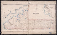
Plan of Georgetown, Georgetown Common, and Georgetown Royalty
Description: Plan of Georgetown, Georgetown Common, and Georgetown Royalty. Shows lot numbers. Gives names of a few residents in the Royalty. Also gives nautical soundings for Albion Bay and Brudenell River.
Province: Prince Edward Island
Type: cadastral maps
Date Created: 1828
Plan of part of Town Lots Nos. 54 and 55, and Nos. 91 and 92 in the 2nd Hundred of Town Lots in…
Description: Plan of part of Town Lots Nos. 54 and 55, and Nos. 91 and 92 in the 2nd Hundred of Town Lots in Charlottetown agreeably to the possession of the Misses Stewart according to the original survey of the… more
Province: Prince Edward Island
Type: cadastral maps
Date Created: 1860-07-25

Plan of Lot 48 (No.2)
Description: Plan of Lot 48 (No.2). Shows property of Peter Stewart, Tho. Wright, Tho. DesBrisay, Chas. Stewart, and James Park. Also shows property leased to R. Stewart. Gives location of Battery and the acreage… more
Province: Prince Edward Island
Type: cadastral maps
Incomplete part of Lot 48 (No.130)
Description: Incomplete part of Lot 48 (No.130). Shows the following estates: DesBrisay, Crooke, Cummingham, Cunard, and Lawton. Also gives the names of some residents.
Province: Prince Edward Island
Type: cadastral maps
Plan of the southwestern part of Lot 48 (No.3)
Description: Plan of the southwestern part of Lot 48 (No.3). Gives names of some residents. Shows the location of York Battery and the Reserved Land at Crab Point.
Province: Prince Edward Island
Type: cadastral maps
Map of Lot Forty-Eight: J.H. Meachams and Co. Atlas
Description: Map of Lot 48. Draft for Meacham's Atlas. Also includes inset map of Southport or Stratford (scale: 6 chains/inch). Shows the Charlottetown Royalty, bodies of water such as rivers, and lakes,… more
Province: Prince Edward Island
Type: cadastral maps

Plan of Township No. 2: Compiled from the Proprietors Plans and partial surveys
Description: Plan of Lot 2 (No.5). Compiled from the Proprietors Plans and partial surveys by John Ball, Public Lands Department. Cunard Estate. Shows the names of residents, former occupants, and land conveyance… more
Province: Prince Edward Island
Type: cadastral maps
Date Created: 1885-10
Plan of Lots 49 and 50 showing Loyalist Shares drawn for in Council, 12 February, 1784.
Description: Plan of Lots 49 and 50 showing Loyalist Shares drawn for in Council, 12 February, 1784. Shown are lots and measurements.
Province: Prince Edward Island
Type: cadastral maps

Plan of Lot 54. Incomplete.
Description: Plan of Lot 54. Incomplete. Shows names of some residents, lots, acreage, roads, and bodies of water such as creeks.
Province: Prince Edward Island
Type: cadastral maps
Plan of Lot 54
Description: Plan of Lot 54. Shows names of residents, lots, roads, and bodies of water such as rivers.
Province: Prince Edward Island
Type: cadastral maps

A Plan showing the Position of the Line of Road through, proposes to be run through Lot 47 from…
Description: Plan of existing and proposed road through Lot 47 from George Munn's, West River, to the bridge on the north side of Surveyor's Pond. Distance of 4 miles and 2 chains. Road run under the… more
Province: Prince Edward Island
Type: cadastral maps
Date Created: 1851-08
Plan of a Part of Township No. 35 on the South Side of the Hillsborough River: Those portions…
Description: Plan of part of Lot 35 on the south side of the Hillsborough River showing the property of Rev. John Alister Somerlet MacDonald. Copied from a tracing by W.C. Harris in the Land Office (Plan No.3).… more
Province: Prince Edward Island
Type: cadastral maps
Date Created: 1878

Partial plan of Lot 48
Description: Partial plan of Lot 48. Mainly outline. Shows names of some residents in southern half of Lot. The map shows residents and lots, and roads.
Province: Prince Edward Island
Type: cadastral maps

Plan of Murray River Lot 63: North of the River
Description: Plan of part of Murray River, Lot No.63. Area north of the River and west of Main Street. The map shows residents, lots, acreage, roads, towns, and a nautical compass.
Province: Prince Edward Island
Type: cadastral maps
Date Created: 1958