Displaying 1 - 7 of 7

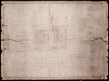
Plan of Lot or Township No. 40: From latest Surveys by Joseph Ball and Owen Curtis, Land Surveyors.
Description: Plan of Lot 40 (No.109). Worrell Estate.
Province: Prince Edward Island
Type: cadastral maps
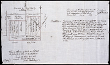
A Plan of 1068 Acres of Land on Lot 40, The Property of Hon. T. H. Haviland
Description: Plan of part of Lot 40 (No.108). 1068 acres of land, the property of Hon. T.H. Haviland. One of the plans referred to in the Deed from Hon. T.H. Haviland and wife to the Commissioner of Public Lands… more
Province: Prince Edward Island
Type: cadastral maps
Date Created: 1868-08
Rural Directory - Lot 39, Kings County : Rural Directory - Lots 40 - 41, Kings County
Description: A directory listing of residents of Lots 39, 40, and 41.
Province: Prince Edward Island
Date Issued (Source): 1927
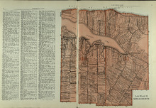
Lots 40 and 41: Kings County
Description: The map shows lots 40 and 41 in Kings county. Shown are the Gulf of St. Lawrence, St. Peters Bay, landowners, acreage, roads, and railroads.
Publisher: Cummins Map Co.
Province: Prince Edward Island
Type: cadastral maps
Date Issued (Source): 1927
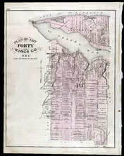
Plan of Lot Fourty: Kings Co., P.E.I.
Description: The map shows Lot 40 in Kings county. Shown are a bay, gulf, river, ponds, school house, churches, wharf, post office, roads, landowners and acreage, and mills. Compass.
Publisher: J. H. Meacham & company
Province: Prince Edward Island
Type: cadastral maps
Date Issued (Source): 1880
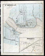
Cardigan Lot 53: Morrell Lot 40
Description: The map shows lot 53 in Cardigan. Shown are a river, roads, railroads, lots, landowners, school house, buildings, houses, wharfs and creeks. Compass.
Publisher: J. H. Meacham & company
Province: Prince Edward Island
Type: cadastral maps
Date Issued (Source): 1880