Displaying 1 - 2 of 2
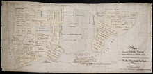
Plan of part of Township Number 35 situate on the North side of the Hillsborough River.: Those…
Description: Plan of Lot 35 (No.1). North side of the Hillsborough River. Property of Rev. John MacDonald. From a tracing by W.C. Harris. The map shows lots, residents, roads, and bodies of water.
Province: Prince Edward Island
Type: cadastral maps
Date Created: 1878-03-21
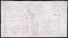
Plan if the Southren Moiety of Township No 36 Part of the Estate of the Rev: John Alister Somerlet…
Description: Plan of the southern moiety of Lot 36 (No.2). Part of the estate of the Rev. John Alister Somerlet MacDonald. From a tracing by W.C. Harris. The map shows lots, residents, a pond, and roads.
Province: Prince Edward Island
Type: cadastral maps
Date Created: 1878-03-22