Displaying 1 - 27 of 176

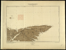
Prince Edward Island Nova Scotia and New Brunswick: Prince, Queens and Kings Counties, P.E.I.…
Description: Prince, Queens and Kings Counties, Prince Edward Island, portions of New Brunswick, Nova Scotia, and Magdalen Islands. It marks counties, parishes, cities, towns, and villages, beaches, marshes, Lots… more
Publisher: Hydrographic and Map Service, Labelle Building
Province: Prince Edward Island, Nova Scotia, New Brunswick, Quebec
Type: cadastral maps
Date Created: 1940

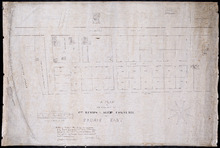
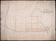
Plan of a Line of Road from Montague River Bridge to Wood Islands: Run in November 1833
Description: Plan of a line of road from Montague River Bridge to Wood Islands. Passes through Lots 59, 60, 61, and 62. (No.59). Shown are residents, lots, and rivers.
Province: Prince Edward Island
Type: cadastral maps
Date Created: 1833-11
P.E.I. Railway: Elmira Branch Plan of Right-of-Way
Description: Prince Edward Island Railway. Elmira Branch. Plan of Right-of-Way (No.429, Kings Co.). Plan created by Wm. B. MacKenzie, Chief Engineer. The map shows lots, roads, residents, and acreage.
Province: Prince Edward Island
Type: cadastral maps
Date Created: 1909-06-02

Map of Prince Edward Island
Description: Map of Prince Edward Island showing school districts(?). The map shows bodies of water and town and cities.
Province: Prince Edward Island
Type: cadastral maps, thematic maps
Date Created: 1971-02-05
Prince Edward Island
Description: Prince Edward Island. Geological Survey of Canada. The map shows Kings county roads, cities and towns.
Province: Prince Edward Island
Type: geological maps
Date Created: 1884

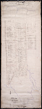
Plan of Township No. 63: compiled from the proprietors' plans, descriptions in leases and…
Description: Plan of Lot 63 compiled from the proprietors' plans, descriptions in leases and registered deeds, and from Meacham's Atlas, with additions and corrections from surveys made at various times… more
Province: Prince Edward Island
Type: cadastral maps
Date Created: 1921-02
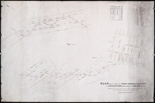
A Plan of the Property of Capt. Simon and Alexander Cheverie: in Souris East
Description: A plan of the property of Capt. Simon and Alexander Cheverie in Souris East. The map shows lots, acreage, roads/streets, and buildings.
Province: Prince Edward Island
Type: cadastral maps
Date Created: 1879-06-18

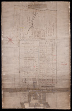
Plan of George Town: The Town Lots are 84 by 120 Feet. The North and South Streets are 100 Feet.…
Description: Plan of Georgetown showing lots and streets, bays, ranges, squares, and a school house. Also shows location of school house. Copy from the Office Plan No.6.
Province: Prince Edward Island
Date Created: 1853-06-07

Plan de l'Ȋle de St. Jean au Nord de l'Acadie et dans le Sud du Golfe de St. Laurent.:…
Description: Plan de l'Ȋle de St. Jean. Par Ordre de M. de Sartine, Conseiller d'Etat, Ministre et Secretaire d'Etat au Département de la Marine. The map shows the province of Prince Edward Island… more
Publisher: Sartine, M. de
Province: Prince Edward Island
Type: topographic maps
Date Created: 1778
Plan Shewing Lands in the Town, Common, and Royalty of Georgetown appropriated for Railway purposes…
Description: Plan showing lands in the Town, Common, and Royalty of Georgetown appropriated for Railway Purposes. The map shows residents, acreage, roads, and harbours.
Province: Prince Edward Island
Type: cadastral maps

Plan of that part of Lot or Township No. 55, lying North: lying North of Boughton River shewing the…
Description: Plan of that part of Lot or Township 55 lying north of Boughton River showing the situation of the respective plots as coloured green which are still in the Crown. The map shows bodies of water such… more
Province: Prince Edward Island
Type: cadastral maps
Date Created: 1845
Plan of Township No. 47 in Prince Edward Island: compiled from the old plans and surveys on file in…
Description: The map, which appears to be incomplete, shows Lot 47 divided into parcels of land with names of residents, acreage amounts and land conveyance references. The map shows roads, rivers, streams and… more
Province: Prince Edward Island
Type: cadastral maps

Plan of Township No. 64: compiled from the proprietors' plans, descriptions in leases and…
Description: The map shows Lot 64 divided into parcels of land with names of residents, their acreage amounts and land conveyence references. Land information written in black indicates government land;… more
Province: Prince Edward Island
Type: cadastral maps
Date Created: 1920
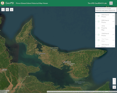
GeoPEI: Prince Edward Island Historical Map Viewer
Description: GeoPEI is a web portal developed by Dr. Josh MacFadyen and students in the GeoREACH Lab. Its purpose is to share maps, atlases, aerial photos, and geospatial data in an online map (aka. a webmap)… more
Publisher: UPEI GeoREACH Lab
Province: Prince Edward Island
Type: aerial photographs, cadastral maps
Date Created: 2024
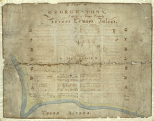
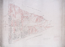
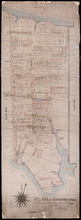
Plan of George-Town: Capital of Kings County, Prince Edward Island
Description: A hand-drawn map of Georgetown, PEI that includes the layout of the town including Kent Square, the ranges, house lots, water lots, and buildings. Three Rivers borders the town.
Province: Prince Edward Island
Date Created: 1835
Plan of the Estate of the Hon. Spencer Cecil Brabazon Ponsonby Fane Situate on Lot or Township No.…
Description: Plan of Lot 53 showing the estate of the Hon. Spencer Cecil Brabazon Ponsonby Fane. Copied by R.T. Weeks. Shows names and acreage of some residents, roads, and rivers such as Morell.
Province: Prince Edward Island
Type: cadastral maps

Plan of Lot or Township No. 53, shewing the positions of the respective boundaries thereof. Those…
Description: Plan of Lot 53 showing the position of the boundaries of the Melville, Selkirk and Westmoreland Estates (No.5). Shows names and acreage of a few residents, bodies of water such as rivers (Brudnell),… more
Province: Prince Edward Island
Type: cadastral maps

Royalty of Georgetown
Description: Plan of Lot 53 showing the estate of Lady Westmoreland. Shows names of residents and acreage, roads, and bodies of water such as rivers (Montague). Also shows the division line between the estate of… more
Province: Prince Edward Island
Type: cadastral maps
Plan Township No. 53. comprising parts of the Melville, Selkirk, and Fane Estates. Compiled and…
Description: Plan of Lot 53 comprising parts of the Melville, Selkirk and Fane Estates (No.144). Shows names, acreage, and land conveyance references for some residents, bodies of water such as rivers, and… more
Province: Prince Edward Island
Type: cadastral maps
Plan of Pierce Gaul's Estate Montague-Bridge
Description: Plan of Pierce Gaul's Estate, Montague Bridge, Lot No.52. The map shows the Montague River, streets, and buildings. more
Province: Prince Edward Island
Type: cadastral maps
Date Created: 1877-05

Plan of Lot or Township No. 51 in Kings County P. E. Island
Description: Plan of Lot 51 (No.139) Colour code shows freehold and unsold portions. Sir Graham Montgomery Estate. Shows names, acreage, and land conveyance references of some residents, and roads.
Province: Prince Edward Island
Type: cadastral maps
Lot 45 (No.122)
Description: Plan of the northeastern part of Lot 45 (No.122). Shows names of residents and acreage and a nautical compass.
Province: Prince Edward Island
Type: cadastral maps
Plan of Township No. 44. Corrected from Surveys by Owen Curtis, J. C. Underhay and others. By Thos…
Description: Plan of Lot 44 (No.118) corrected by Thomas MacKinlay from surveys by Owen Curtis, J.C. Underhay and others. Cunard Estate. Shows some residents' names, acreage, and land conveyance references,… more
Province: Prince Edward Island
Type: cadastral maps
Date Created: 1887-09
Plan of Township No. 44.
Description: Plan of Lot 44 (No.120). Cunard Estate. Shows names and acreage of some residents, bodies of water such as rivers and gulfs, roads, and a mills (MacGowans).
Province: Prince Edward Island
Type: cadastral maps
A Plan of Lot or Township No. 43, Comprising the Haviland, Townsend, and Worrell Estates. Compiled…
Description: Plan of Lot 43 (No.116) comprising the Haviland, Townshend, and Worrell Estates. Completed from the surveys of J. Ball and J.C. Underhay by Owen Curtis. Shows names of residents, acreage, and land… more
Province: Prince Edward Island
Type: cadastral maps
Date Created: 1876-08

Plan of Lot 42 (No.112)
Description: Plan of Lot 42 (No.112). Shows names and acreage of some residents, bodies of water, and roads.
Province: Prince Edward Island
Type: cadastral maps

Pla of Lot or Township No. 42
Description: Plan of Lot 42 (No.113). Worrell Estate. Shows names of residents, acreage, and land conveyance references.
Province: Prince Edward Island
Type: cadastral maps