Displaying 1 - 12 of 12
Plan of Township No. 31: compiled from the proprietors plans and Meacham's Atlas and from the…
Description: Plan of Lot 31 compiled from the Proprietors' plans and Meacham's Atlas and from the descriptions in leases and registered deeds, with additions and corrections from various surveys made… more
Province: Prince Edward Island
Type: cadastral maps
Date Created: 1917-12

Plan of Township No. 57: Compiled from the proprietors plans and Meacham's Atlas, and from the…
Description: The map shows Lot 57 divided into parcels of land with names of residents, acreage amounts and land conveyance references. Areas drawn in black indicate land conveyed to the government and re-… more
Province: Prince Edward Island
Type: cadastral maps
Date Created: 1917
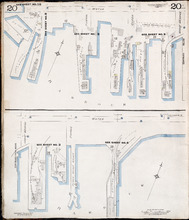
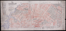
Charlottetown P.E.I.: July 1917. Reprinted.
Description: This is Page 20 of 20 pages of fire insurance maps of Charlottetown. It shows Water Street in two (2) sections that are intended to be continuous. The section at the top of the page shows Water… more
Publisher: Chas. E. Goad, Civil Engineer
Province: Prince Edward Island
Type: fire insurance maps
Date Created: 1917-07
Date Issued (Source): 1888

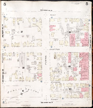
Summerside P.E.I.: Aug. 1917. Reprinted.
Description: This is Page 2 of 11 pages of fire insurance maps of Summerside. It shows the area from Market Street North to the waterfront, between Duke and Central streets. The map shows numbered town blocks and… more
Publisher: Chas. E. Goad, Civil Engineer
Province: Prince Edward Island
Type: fire insurance maps
Date Created: 1917-08
Date Issued (Source): 1888

Summerside P.E.I.: Aug 1917. Reprinted
Description: This is Page 3 of 11 pages of fire insurance maps of Summerside. This map shows the area from Church Street to the waterfront, between Central and Granville streets. The map shows numbered town… more
Publisher: Chas. E. Goad, Civil Engineer
Province: Prince Edward Island
Type: fire insurance maps
Date Created: 1917-08
Date Issued (Source): 1888

Summerside, P.E.I.: Aug. 1917. Reprinted
Description: This is Page 4 of 11 pages of fire insurance maps of Summerside. (An older version of this town section is shown on Summerside_p4_1910.) The map shows the area from Belmont Street to the waterfront,… more
Publisher: Chas. E. Goad, Civil Engineer
Province: Prince Edward Island
Type: fire insurance maps
Date Created: 1917-08
Date Issued (Source): 1888
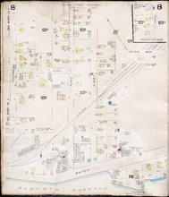
Summerside, P.E.I.: July 1903
Description: This is Page 8 of 11 pages of fire insurance maps of Summerside. It was created in 1903 and revised to 1917. It shows an area from the Kirk Street vicinity to the waterfront, east of Russell Street.… more
Publisher: Chas. E. Goad, Civil Engineer
Province: Prince Edward Island
Type: fire insurance maps
Date Created: 1903-07
Date Modified: 1917-08 (year and month uncertain)
Date Issued (Source): 1888
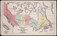
Fire Underwriters Map of Canada Showing Territory Under Jurisdiction of Rating Bureaus: Issued by…
Description: This map shows Canada in context with parts of the United States and Greenland. It shows the provinces and territories in different colours and gives the names of the various insurance underwriters… more
Publisher: Ream, Ives and Wrightson, Inc
Date Created: 1917
Date Issued (Source): 1888
Charlottetown, Prince Edward Island: July 1917. Reprinted
Description: This is Page 2 of 20 pages of fire insurance maps of Charlottetown. It shows the area from Sidney Street to the waterfront, between Haviland and Queen streets. The map shows numbered city blocks and… more
Publisher: Chas. E. Goad, Civil Engineer
Province: Prince Edward Island
Type: fire insurance maps
Date Created: 1917-07
Date Issued (Source): 1888
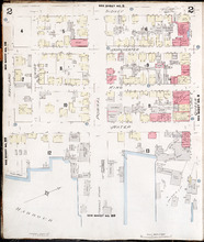
Charlottetown, Prince Edward Island: July 1917. Reprinted
Description: This is Page 3 of 20 pages of fire insurance maps of Charlottetown. It shows the area from Sidney Street to the waterfront, between Queen and Prince streets. The map shows numbered city blocks and… more
Publisher: Chas. E. Goad, Civil Engineer
Province: Prince Edward Island
Type: fire insurance maps
Date Created: 1917-07
Date Issued (Source): 1888
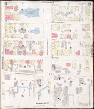
Charlottetown, P.E.I.: July 1917. Reprinted
Description: This is Page 5 of 20 pages of fire insurance maps of Charlottetown. It shows the area from Kent Street to Sidney Street, between Rochford and Queen streets. The map shows numbered city blocks and the… more
Publisher: Chas. E. Goad, Civil Engineer
Province: Prince Edward Island
Type: fire insurance maps
Date Created: 1917-07
Date Issued (Source): 1888
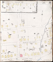
Charlottetown P.E.I.: July 1917. Reprinted
Description: This item, Page 11 of 20 pages of fire insurance plans of Charlottetown, consists of two (2) maps. The main map shows the area from Green Street to Brighton Road, between Greenfield Avenue (Second)… more
Publisher: Chas. E. Goad, Civil Engineer
Province: Prince Edward Island
Type: fire insurance maps
Date Created: 1917-07
Date Issued (Source): 1888