Displaying 1 - 43 of 43
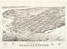
Panoramic view of Charlottetown, Prince Edward Island: 1878
Description: Panoramic, bird's eye view of Charlottetown from the harbour. Ships of various kinds, including sail and steam-powered, pictured in the foreground. View shows a busy, industrial waterfront with… more
Publisher: Prince Edward Island Museum and Hertiage Foundation
Province: Prince Edward Island
Type: bird's-eye views
Date Issued: 1983
Date Created: 1878
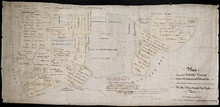
Plan of part of Township Number 35 situate on the North side of the Hillsborough River.: Those…
Description: Plan of Lot 35 (No.1). North side of the Hillsborough River. Property of Rev. John MacDonald. From a tracing by W.C. Harris. The map shows lots, residents, roads, and bodies of water.
Province: Prince Edward Island
Type: cadastral maps
Date Created: 1878-03-21
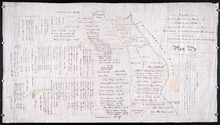
Plan if the Southren Moiety of Township No 36 Part of the Estate of the Rev: John Alister Somerlet…
Description: Plan of the southern moiety of Lot 36 (No.2). Part of the estate of the Rev. John Alister Somerlet MacDonald. From a tracing by W.C. Harris. The map shows lots, residents, a pond, and roads.
Province: Prince Edward Island
Type: cadastral maps
Date Created: 1878-03-22
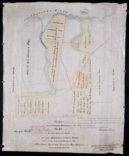
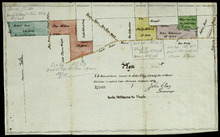
Plan of a Part of Township No. 35 on the South Side of the Hillsborough River: Those portions…
Description: Plan of part of Lot 35 on the south side of the Hillsborough River showing the property of Rev. John Alister Somerlet MacDonald. Copied from a tracing by W.C. Harris in the Land Office (Plan No.3).… more
Province: Prince Edward Island
Type: cadastral maps
Date Created: 1878

Plan of Township No. 13: From a Survey by Alex Anderson Copied from a Plan made by John Clay…
Description: Plan of Lot 13 - Yeo Estate.
Province: Prince Edward Island
Type: cadastral maps
Date Created: 1878

Plan Shewing the Eligible Situation of Acre Lots on the Estate of the Honble. J. C. Pope. in the…
Description: Plan showing the eligible situation of acre lots on the estate of Hon. J.C. Pope in the Royalty of the city of Charlottetown. Royalty Lots No.85, No.95 and No.97. (No.386)
Province: Prince Edward Island
Type: cadastral maps
Date Created: 1878

Plan of St. Avard's divided into Building Lots part of the Estate of the Honble. James C. Pope…
Description: Plan of St. Avards divided into building lots, part of the estate of the Hon. James C. Pope in the Royalty of Charlottetown. Royalty Lot No.13. Also shown are St. Peters Road, and Mt. Stewart Road.
Province: Prince Edward Island
Type: cadastral maps
Date Created: 1878
Plan of 75 Acres of land leased to John Clay, showing the different divisions in which it was…
Description: Plan of part of Lot 26. The plan shows 75 acres of land in the western part of Lot 26 leased to John Clay and then later divided and conveyed to other individuals. The plan shows names of residents… more
Province: Prince Edward Island
Type: cadastral maps
Date Created: 1878-08-05

Geological Maps of the Maritime Province: of the Dominion of Canada
Description: The map shows the geology of the Maritime Province. Shown are provinces of New Brunswick, Nova Scoita and Cape Breton Island, Prince Edward Island, and Newfoundland as an insert. Other objects shown… more
Publisher: Roe Brothers
Province: Prince Edward Island, New Brunswick, Nova Scotia, Cape Breton Island
Type: geological maps
Date Issued (Source): 1878
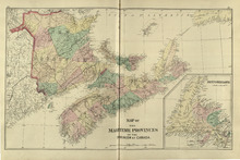
Map of the Maritime Provinces: of the Dominion of Canada
Description: The map shows the geology of the Maritime Province. Shown are provinces of New Brunswick, Nova Scoita and Cape Breton Island, Prince Edward Island, and Newfoundland as an insert. Other objects shown… more
Publisher: Roe Brothers
Province: Prince Edward Island, New Brunswick, Nova Scotia, Cape Breton Island
Type: geological maps
Date Issued (Source): 1878
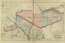
Counties of Restigouche and Madawaska: New Brunswick
Description: The maps shows the counties of Restigouche and Madawaska. Shown are Resitgouche Harbour, cities, towns, and lakes.
Publisher: Roe Brothers
Province: New Brunswick
Type: geographical maps
Date Issued (Source): 1878
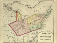
County of Gloucester: New Brunswick
Description: The map shows the county of Gloucester in New Brunswick. Shown are bays, railroads and stations, harbours, rivers, roads, towns and cities.
Publisher: Roe Brothers
Province: New Brunswick
Type: geological maps
Date Issued (Source): 1878
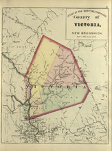
County of Victoria: New Brunswick
Description: The maps shows the county of Victoria in New Brunswick. Shown are rivers, brooks, Grand Falls, railroads and stations.
Publisher: Roe Brothers
Province: New Brunswick
Type: geographical maps
Date Issued (Source): 1878
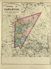
County of Carleton: New Brunswick
Description: The map shows the county of Carleton in New Brunswick. Shown are raods, railroads, towns, cities, and lakes.
Publisher: Roe Brothers
Province: New Brunswick
Type: geographical maps
Date Issued (Source): 1878
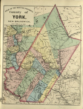
County of York: New Brunswick
Description: The map shows the county of York in New Brunswick. Shown are railroads and stations, St. Mary Ferry, Nashwaak Bridge, mills, lakes, MacAdam Junction, post offices, cities, and towns.
Publisher: Roe Brothers
Province: New Brunswick
Type: geographical maps
Date Issued (Source): 1878
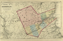
County of Northumberland: New Brunswick
Description: The map shows the county of Northumberland in New Brunswick. Shown are bays, lakes, rivers, railroads, towns, and cities.
Publisher: Roe Brothers
Province: New Brunswick
Type: geological maps
Date Issued (Source): 1878
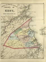
County of Kent: New Brunswick
Description: The map shows the county of Kent in New Brunswick. Shown are bays, rivers, mills, braches, Langhilins road, and Shediac Bridge.
Publisher: Roe Brothers
Province: New Brunswick
Type: geological maps
Date Issued (Source): 1878
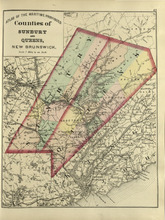
Counties of Sunbury and Queens: New Brunswick
Description: The map shows the counties of Sunbury and Queens in New Brunswick. Shown are railroads, stations and junctions, rivers, lakes, and creeks.
Publisher: Roe Brothers
Province: New Brunswick
Type: geological maps
Date Issued (Source): 1878
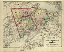
Counties of Westmoreland and Albert: New Brunswick
Description: The map shows the counties of Westmoreland and Albert in New Brunswick. Shown are bays, Cumberland basin. railroads and stations, roads, cities and towns.
Publisher: Roe Brothers
Province: New Brunswick
Type: geological maps
Date Issued (Source): 1878
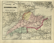
County of Cumberland: Nova Scotia
Description: The map shows the county of Cumberland in Nova Scotia. Shown are bays, channels, basins, mountains, rivers, railroads and stations, lakes, cities and towns.
Publisher: Roe Brothers
Province: Nova Scotia
Type: geological maps
Date Issued (Source): 1878
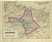
County of Colchester: Nova Scotia
Description: The map shows the county of Colchester in Nova Scotia. Shown are railroads and stations, basins, rivers, mountains, cities and towns.
Publisher: Roe Brothers
Province: Nova Scotia
Type: geological maps
Date Issued (Source): 1878
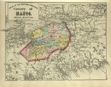
County of Hants: Nova Scotia
Description: The map shows the county of Hants in Nova Scotia. Shown are basins, lakes, gold mines, railroads, stations, and rivers.
Publisher: Roe Brothers
Province: Nova Scotia
Type: geological maps
Date Issued (Source): 1878
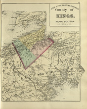
County of Kings: Nova Scotia
Description: The map shows the county of Kings in Nova Scotia. Shown are bays, brooks, creeks, lakes, railroads and stations, mines, roads, cities and towns.
Publisher: Roe Brothers
Province: Nova Scotia
Type: geological maps
Date Issued (Source): 1878
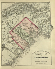
County of Lunenburg: Nova Scotia
Description: The map shows the county of Lunenburg in Nova Scotia. Shown are railroads abd stations, roads, rivers, bays, coves, basins, lakes, and harbours.
Publisher: Roe Brothers
Province: Nova Scotia
Type: geological maps
Date Issued (Source): 1878
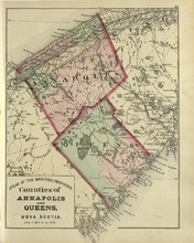
Coutnies of Annapolis and Queens : Nova Scotia
Description: The map shows the counties of Annapolis and Queens in Nova Scotia. Shown are rivers, roads, railroads, stations, lakes, harbours, cities, and towns.
Publisher: Roe Brothers
Province: Nova Scotia
Type: geological maps
Date Issued (Source): 1878
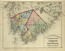
Counties of Yarmouth and Shelburne: Nova Scotia
Description: The map shows the counties of Yarmouth and Shelburne in Nova Scotia. Shown are railroads, stations, capes, coves, rivers, lakes, and harbours.
Publisher: Roe Brothers
Province: Nova Scotia
Type: geological maps
Date Issued (Source): 1878
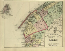
County of Digby: Nova Scotia
Description: The map shows the county of Digby in Nova Scotia. Shown are coves, rivers, capes, lakes, roads, railroads, bridges, cities and towns.
Publisher: Roe Brothers
Province: Nova Scotia
Type: geological maps
Date Issued (Source): 1878
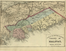
County of Halifax: Nova Scotia
Description: The map shows the county of Halifax in Nova Scotia. Shown are harbours, rivers, lakes, bays, gold mines, towns, and cities.
Publisher: Roe Brothers
Province: Nova Scotia
Type: geological maps
Date Issued (Source): 1878
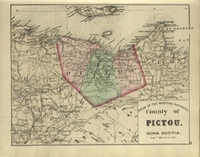
County of Pictou: Nova Scotia
Description: The map shows the county of Pictou in Nova Scotia. Shown are channel, rivers, lakes, harbours, railroads, lakes, mills, towns, and cities.
Publisher: Roe Brothers
Province: Nova Scotia
Type: geological maps
Date Issued (Source): 1878
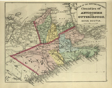
Couties of Antigonish and Guysborough: Nova Scotia
Description: The map shows the counties of Antigonish and Guysborough in Nova Scotia. Shown are rivers, bays, capes, lakes, points, roads, railroads, coves, harbours, cities, and towns.
Publisher: Roe Brothers
Province: Nova Scotia
Type: geological maps
Date Issued (Source): 1878
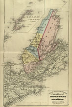
Counties of Inverness and Victoria: Nova Scotia
Description: The map shows the counties of Inverness and Victoria in Nova Scotia. Shown are bays, lakes, rivers, coves, gold mines, islands, harbours, cities, and towns.
Publisher: Roe Brothers
Province: Nova Scotia
Type: geological maps
Date Issued (Source): 1878
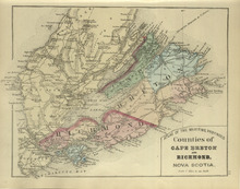
Counties of Cape Breton and Richmond: Nova Scotia>
Description: The map shows the counties of Cape Breton and Richmond in Nova Scotia. Shown are bays, lakes, points, channels, harbours, roads, railroads, towns, and cities.
Publisher: Roe Brothers
Province: Nova Scotia
Type: geological maps
Date Issued (Source): 1878
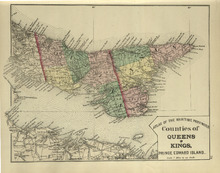
Counties of Queens and Kings: Prince Edward Island
Description: The map shows the counties of Queens and Kings in Prince Edward Island. Shown are bays, points, rivers, capes, coves, harbours, roads, railroads, cities, and towns.
Publisher: Roe Brothers
Province: Prince Edward Island
Type: geological maps
Date Issued (Source): 1878
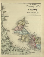
County of Prince: Prince Edward Island
Description: The map shows the county of Prince in Prince Edward Island. Shown are capes, bays, coves, roads, railroads, cities and towns.
Publisher: Roe Brothers
Province: Prince Edward Island
Type: geological maps
Date Issued (Source): 1878
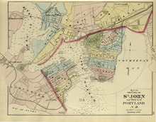
Map of the City of St. John and Town of Portland: N.B.
Description: The map shows the City of St. John and Town of Portland in New Brunswick. Shown are bays, rivers, harbour, lots, acreage, roads, railroads, towns, buildings, and names.
Publisher: Roe Brothers
Province: New Brunswick
Type: geological maps
Date Issued (Source): 1878
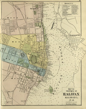
Map of the City of Halifax: Halifax Co. N.S.
Description: The map shows the city of Halifax, Halifax County in Nova Scotia. Shown are a Reference table, Halifax Harbour, pond, roads, wards, lots, buildings, and landowners.
Publisher: Roe Brothers
Province: Nova Scotia
Type: geographical maps
Date Issued (Source): 1878
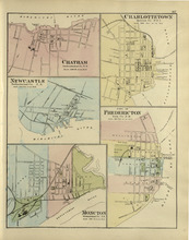
Chatham : Charlottetown : New Castle : City of Fredricton : Moncton: Northumberland Co. N.B..…
Description: The map shows Catham in the Northumberland county. New Brunswick. Shown are a river, wharf, streets, buildings, lots and a ferry crossing. The map shows Charlottetown in Queens county, Prince Edward… more
Publisher: Roe Brothers
Province: New Brunswick, Prince Edward Island
Type: geographical maps
Date Issued (Source): 1878
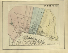
St. Stephen
Description: The map shows St. Stephen. Shown are a railroad and station, lots, wards, roads, buildings, and St. Croix River.
Publisher: Roe Brothers
Province: New Brunswick
Type: geographical maps
Date Issued (Source): 1878
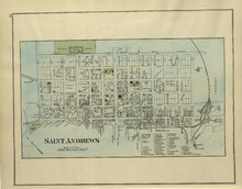
St. Andrews
Description: The map of St. Andrews. Shown are a Reference table, railroads and station, military lands, roads, lots, owners, and wharfs.
Publisher: Roe Brothers
Province: New Brunswick
Type: geographical maps
Date Issued (Source): 1878
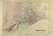
Moncton
Description: The map shows Moncton. Shown are a References table, wards, roads, railways and station, lots, buildings, landowners, and Petitcodiac River.
Publisher: Roe Brothers
Province: New Brunswick
Type: geographical maps
Date Issued (Source): 1878
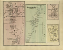
Hillsborough : Hopewell Cape : Salisbury : Hopewell Corner
Description: The map shows Hillsborough. Shown are buildings, lots, landowners, districts, Mill creek, wharfs, railways, post offices and shops. The map shows Hopewell Cape. Shown are buildings, landowners, roads… more
Publisher: Roe Brothers
Province: New Brunswick
Type: geographical maps
Date Issued (Source): 1878
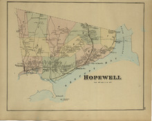
Hopewell
Description: The map shows Hopewell. Shown are a bay, island, rivers, wharf, railway and station, roads, landowners, and mountains.
Publisher: Roe Brothers
Province: New Brunswick
Type: geographical maps
Date Issued (Source): 1878