Displaying 1 - 6 of 6
Plan of Lot 58
Description: Plan of Lot 58 divided into four sections. Shows Refugee Shares drawn for 12th February, 1784. Shown are lots, residents, and bodies of water.
Province: Prince Edward Island
Type: cadastral maps
Date Created: 1784-02-12
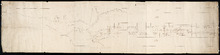
Plan of Lot 31
Description: Plan of Lot 31 (No.2). Mainly outline. Shows Refugee Share drawn for in Council, 12 February, 1784. Signed by John Russell Spence, Clerk of the Council.
Province: Prince Edward Island
Type: cadastral maps
Date Created: 1784

Lot 30: Refugee Share drawn for in Council this 18th day of September 1784, John Spencer
Description: Plan of Lot 30 (No.1) showing Refugee Shares drawn for in Council, 18 September, 1784.
Province: Prince Edward Island
Type: cadastral maps
Date Created: 1784

L'ACADIE: Par le Sr. Robert de Vaugindy Fils de Mr. Robert Geogr. ord, du Roy, Avec Privilege
Description: Period designation 18th century. The map shows bodies of water such as Baye Francoise, villages, towns, cities, mountains, trees, islands, and banks.
Province: Nova Scotia, Prince Edward Island
Type: topographic maps
Date Created: Unknown year in the century of the 1700s

Carta Geographica Del Canada Nell' America Settentrionale
Description: Framed map of Canada; cartouche top left corner: natives by a pond with deer and animals which are part dog, part fish. The map shows bodies of water such as Baja D' Hudson, villages, towns, and… more
Type: chorographic maps
Date Created: 1700 to 1799
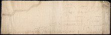
Plan of Lot 57
Description: Plan of Lot 57 (No.2) showing the lot divided into quarters. Also shows Refugee Share drawn for in Council, 12 February, 1784.
Province: Prince Edward Island
Type: cadastral maps
Date Created: 1784-02-12