Displaying 1 - 4 of 4
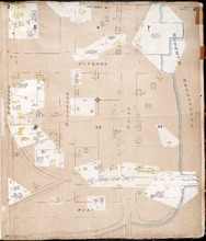
Georgetown P.E.I.: Oct. 1893
Description: This is the second of two (2) pages of fire insurance maps of Georgetown. It was created in 1893 and revised to 1910. The map concentrates on an area one and a half blocks east from West Street,… more
Publisher: Chas. E. Goad, Civil Engineer
Province: Prince Edward Island
Type: fire insurance maps
Date Created: 1893-10
Date Modified: 1910-09
Date Issued (Source): 1888
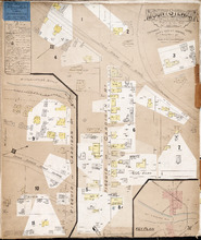
Mount Stewart Prince Edward Island: Population 400. No Appliances. October 1893.
Description: This is a fire insurance plan of the village of Mount Stewart consisting of two maps--one for each side of the Hillsborough River. It was created in 1893 and revised to 1910. The smaller map, on the… more
Publisher: Chas. E. Goad, Civil Engineer
Province: Prince Edward Island
Type: fire insurance maps
Date Created: 1893-10
Date Modified: 1910-09
Date Issued (Source): 1888
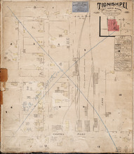
Tignish. P.E.I.: Population 500. No appliances. October 1888
Description: This is an older (1888, revised to 1893) version of a fire insurance plan of the village of Tignish. A more updated plan is shown on the map Tignish_1910. The map shows the area near Chapel Road and… more
Publisher: Chas. E. Goad, Civil Engineer
Province: Prince Edward Island
Type: fire insurance maps
Date Created: 1888-10
Date Modified: 1893-10
Date Issued (Source): 1888
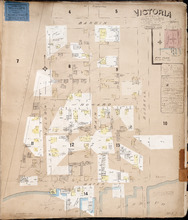
Victoria P.E.I.: Population 300. No appliances. Chas E Goad Civil Engineer Toronto & Montreal.…
Description: This is a fire insurance plan of the village of Victoria. It was created in 1893 and revised to October, 1910. It shows the area from Bardin Street to the waterfront, between Nelson and Russell… more
Publisher: Chas. E. Goad, Civil Engineer
Province: Prince Edward Island
Type: fire insurance maps
Date Created: 1893-10
Date Modified: 1910-10
Date Issued (Source): 1888