Displaying 1 - 6 of 6

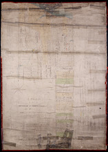
Plan of that portion of the town of Summerside laid off on the front of the farm by Mr. Jesse Green.
Description: Plan of that portion of the town of Summerside laid off on the front of the farm by Mr. Jesse Green. The map shows lots, residents, towns, cities, roads, and bodies of water.
Province: Prince Edward Island
Type: cadastral maps
Date Created: 1868-11-25

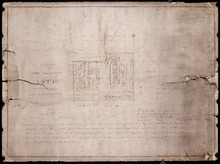
Plan showing the situation of the line of road from Melville Road to Appin Road also the connecting…
Description: Plan showing the situation of the line of road from Melville Road to Appin Road; also, the connecting road leading to Crapaud Wharf. Roads pass through Lots 29 and 30. (No.15, Queen's). Shown… more
Province: Prince Edward Island
Type: cadastral maps
Date Created: 1868-06-08
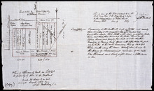
A Plan of Part of Township No. Forty Three. The Property of Hon. T. H. Haviland. Surveyed October…
Description: Plan of part of Lot 43. The property of Hon. T.H. Haviland. One of the plans referred to in the Deed from Hon. T.H. Haviland and wife to the Commissioner of Public Lands, 1869. Shows names and… more
Province: Prince Edward Island
Type: cadastral maps
Date Created: 1868-10
A Plan of 1068 Acres of Land on Lot 40, The Property of Hon. T. H. Haviland
Description: Plan of part of Lot 40 (No.108). 1068 acres of land, the property of Hon. T.H. Haviland. One of the plans referred to in the Deed from Hon. T.H. Haviland and wife to the Commissioner of Public Lands… more
Province: Prince Edward Island
Type: cadastral maps
Date Created: 1868-08
Copy of Plan of part of Lot 27 Prince County P.E.I. Purchased from Hon. J. C. Pope
Description: Copy of plan of part of Lot 27 purchased from Hon. J.C. Pope. The plan is referred to in the Deed from James Colledge Pope and his wife to the Commissioner of Public Lands, July 13, 1868. The map… more
Province: Prince Edward Island
Type: cadastral maps
Date Created: 1868