Displaying 1 - 2 of 2
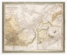
Canada East, Formerly Lower Canada. [with] Nova Scotia, New Brunswick &c.: Published by S.…
Description: The map shows part of Quebec (Canada East) and adjoining parts of New Brunswick and the United States. An inset map shows New Brunswick, Nova Scotia and Prince Edward Island. Colour is used to… more
Publisher: S. Augustus Mitchell
Province: New Brunswick, Nova Scotia, Prince Edward Island, Quebec
Type: topographic maps
Date Created: 1846
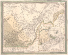
Canada East formerly Lower Canada
Description: Includes Quebec and Maritimes. Colour by region - primarily beige, yellow, green (compared to other versions of this map, the colours are muted). Inset map includes numbered counties for New… more
Publisher: Mitchell, S. Augustus, S. Augustus Mitchell
Province: Prince Edward Island
Date Created: 1846