Displaying 1 - 5 of 5

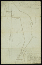
Office copy of that part of the Plan of the new line of Road leading from the Cardigan River to the…
Description: Plan of the new line of road leading from the Cardigan River to the Hillsborough River. Passes through Lots 51, 52, and 38. Plan copied by Geo. Wright, 12 August, 1837. The plan uses a dashed and… more
Province: Prince Edward Island
Type: engineering maps
Date Created: 1833
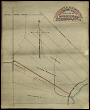
Plan of land appropriated by the Railway Commissioners in Lots 38 and 51
Description: Prince Edward Island Railway. Plan shows the land appropriated by the Railway Commissioners in Lots 38 and 51. The rail line is drawn in pink. Roads are shown in a lighter colour. Names of residents… more
Province: Prince Edward Island
Type: engineering maps
Plan of Proposed Road on A. Dickerson's Farm Township No. 23: Surveyed by John P. Nicholson P…
Description: Plan of proposed road on A. Dickerson's Farm on Lot 23. (No.53). The plan shows a proposed new road, coloured orange, through Arthur Dickerson's farm between Rennie Road and St. Mary's… more
Province: Prince Edward Island
Type: engineering maps
A Draugth of the new road opened by order of his Excellency Governor Smith, for the west settlement…
Description: Plan of part of Lot 34 (No.41). This plan shows a new road in the Covehead area in the northwest corner of Lot 34. It describes the land surrounding the road with labels noting swamp or hardwood… more
Province: Prince Edward Island
Type: engineering maps
Date Created: 1824