Displaying 1 - 9 of 9

Lot 6: No. 19
Description: Plan of Lot 6 (No. 19). Cunard Estate. Shows names of residents, acreage, and some land conveyance references, bodies of water such as rivers, and roads.
Province: Prince Edward Island
Type: cadastral maps
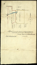
Plan shewing the situation of a Mill-pond Right on Lots 6 and 7, purchased from Samuel Sweet, by…
Description: Plan of part of Lots 6 and 7 showing the situation of a Mill-pond right purchased from Samuel Sweet by Richard Smallman and Chas. Crossman. The mill pond is located in the area where Lots 5, 6 and 7… more
Province: Prince Edward Island
Type: cadastral maps
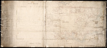
Plan of Township No. 6: Compiled from plans, leases, deeds, and other documents on file in the Land…
Description: The map shows Lot 6 divided into parcels of land with names of residents, their acreage amounts and land conveyance references handwritten in black and red ink. Shows the P.E.I. Railway in red, roads… more
Province: Prince Edward Island
Type: cadastral maps
Date Created: 1912-01
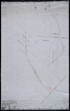
Plan of part of the Railway appropriation in Lots 5 and 6
Description: Plan of part of the Railway appropriation in Lots 5 and 6. Shown are lots, roads, and residents.
Province: Prince Edward Island
Type: cadastral maps, transportation maps
Plan of Lot or Township No. 6 in Prince Edward Island: From Actual Survey by A. Anderson, Land…
Description: Plan of Lot 6. Northern half shows residents.
Province: Prince Edward Island
Type: cadastral maps
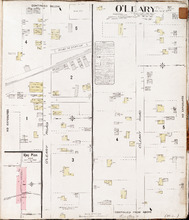
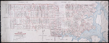
O'Leary P.E.I., Prince Co.: Population 350. No Protection. Oct. 1910
Description: This is a fire insurance plan of O'Leary. It shows the town in two (2) sections that are intended to be continuous. The sections show the area of the O'Leary Road between the Barckley (… more
Publisher: Chas. E. Goad, Civil Engineer
Province: Prince Edward Island
Type: fire insurance maps
Date Created: 1910-10
Date Issued (Source): 1888
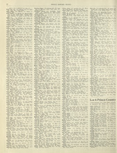
Rural Directory - Lots 4 - 6, Prince County
Description: A directory listing of residents of lots 4, 5, and 6.
Publisher: Cummins Map Co.
Province: Prince Edward Island
Type: text
Date Issued (Source): 1927
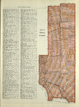
Lot 6: Prince County
Description: The map shows Lot 6 in Prince county. Shown are roads, landowners, acreage, railroad, rivers, and Oyster creek
Publisher: Cummins Map Co.
Province: Prince Edward Island
Date Issued (Source): 1927

Plan of Lot Six: Prince Co., P.E.I.
Description: Map showing lot six, bordering lots 5, 9, 10, 11 in Prince county. Shows rivers, creeks, railroads, roads, landowners, acreage, post offices, and buildings. Geographical compass
Publisher: J. H. Meacham & company
Province: Prince Edward Island
Type: cadastral maps
Date Issued (Source): 1880