IslandImagined
Historic Maps of PEI
Menu
Main navigation
Search
Map Archive
Map Archive sub-navigation
All Maps
... by County
Prince
Queens
Kings
... by Type
Boundary Maps
Cadastral Maps
Chorographic Maps
Fire Insurance Maps
Historical Atlases
Plans
Topographic Maps
Atlases
Cummins Atlas - 1928
Roe Brothers Atlas - 1878
Meacham's Atlas - 1880
Interactive
Interactive sub-navigation
Map Timeline
GeoPEI Map Viewer
Learn More
Learn More sub-navigation
FAQ
Learning Guides
Articles
Online Books
Glossary
Contact
Breadcrumb
Home
Search Content
Displaying 1 - 1 of 1
Results per page
27
54
108
Sort
Relevance β
Relevance β
Title β
Title β
Year β
Year β
Displaying 1 - 1 of 1
Montague Bridge P.E.I.
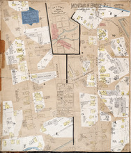
Description:
This is a fire insurance plan of the village of Montague Bridge consisting of two (2) maps--one for each side of the Montague River. It was created in 1888 and revised to 1910. The map on the leftβ¦
more
Publisher:
Chas. E. Goad, Civil Engineer
Province:
Prince Edward Island
Type:
fire insurance maps
Date Created:
1888-10
Date Modified:
1910-09
Date Issued (Source):
1888