Displaying 1 - 9 of 9
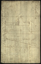
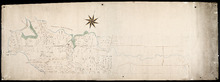
Plan of Railway appropriations in Lots 26, 27 and 28
Description: Plan of Railway appropriations in Lots 26, 27 and 28. The map shows lots, roads, residents, and acreage.
Province: Prince Edward Island
Type: cadastral maps, transportation maps
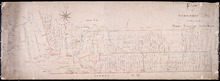
Part of Lot No. 26
Description: Plan of part of Lot 26 (No.3). Plan traced[?] by J. Plaw from a survey by Mr. Major[?]. The maps shows part of Lot 26 (the Centreville area) divided into parcels of land with the names of residents… more
Province: Prince Edward Island
Type: cadastral maps
Date Created: 1810-05-23
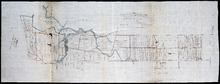
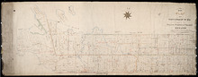
Plan of Township No. 26: Embracing the Thomson Holland and Stephens Estates
Description: Plan of Lot 26 embracing the Thomson, Holland, and Stephens Estates. Shows names of residents, acreage, and land conveyance references, bodies of water such as river, cove, and pond, roads, and a… more
Province: Prince Edward Island
Type: cadastral maps
Plan of the North Moriety of a Township No. 26 the Property if the Messrs Thompson of Belfast…
Description: Plan of the North Moiety of Lot 26, the property of the Messrs. Thompson of Belfast Ireland. Shows names of residents, acreage, and a few land conveyance references, bodies of water such as Bedeque… more
Province: Prince Edward Island
Type: cadastral maps
Date Created: 1875-11-05
Tracing of Plan of the North Moiety of Township No. 26: The property of the Messrs Thompson of…
Description: Tracing of Plan of the North Moiety of Lot 26, the property of the Messrs. Thompson of Belfast, Ireland. Documents attached. The map shows lots, residents, roads, acreage, and bodies of water.
Province: Prince Edward Island
Type: cadastral maps
Date Created: 1875-11-05
Lot 26
Description: Plan of Lot 26, partly finished by T. McKinlay. Residents shown for southern part of lot.
Province: Prince Edward Island
Type: cadastral maps
Plan of Township No. 26: Comprising the Holland, Stephens, and Thomson Estates Copied from the…
Description: Plan of Lot 26 (No.70) comprising the Holland, Stephens, and Thomson Estates copied from the plans in Public Lands Department, corrected by partial surveys and Meacham's Atlas. more
Province: Prince Edward Island
Type: cadastral maps
Date Created: 1885-09
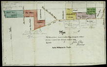
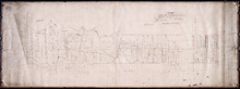
Plan of 75 Acres of land leased to John Clay, showing the different divisions in which it was…
Description: Plan of part of Lot 26. The plan shows 75 acres of land in the western part of Lot 26 leased to John Clay and then later divided and conveyed to other individuals. The plan shows names of residents… more
Province: Prince Edward Island
Type: cadastral maps
Date Created: 1878-08-05
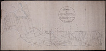
Tracing of Plan of A part of the South Moiety of Lot or Township No. 26 in Prince County in the…
Description: Plan of part of the south moiety of Lot 26, including the property of A. E. C. Holland. Plan drawn by John Clay. The map shows part of the southern half of Lot 26 divided into parcels of land with… more
Province: Prince Edward Island
Type: cadastral maps
Date Created: 1876-05-12