Displaying 1 - 8 of 8
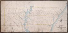
Plan of Township No. 20.: Compiled from Surveys by Jas. Stewart, L. W. Gall, George Wright, Joseph…
Description: Plan of Lot 20. The map shows Lot 20 divided into parcels of land with names of some residents and some acreage amounts. The map notes freehold land. Shows roads in a light brown colour, marsh areas… more
Province: Prince Edward Island
Type: cadastral maps
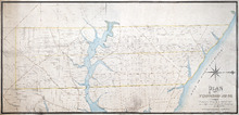
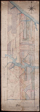
Plan of Township No. 20
Description: Plan of the western moiety of Lot 20 (No.50). Copy of the plan deposited by vendors of the Cunard Estate. The map also shows bodies of water such as rivers, creeks, and ponds, and roads.
Province: Prince Edward Island
Type: cadastral maps
Plan of the Western Moiety of Township, No. 20. Situate in Grenville Parish. Queens Co. P.E.Island…
Description: Plan of the Western Moiety of Lot 20 situate in Grenville Parish (No.49). Includes that part of Lot 20 south of the South West River. Shows names of residents and acreage, bodies of water such as… more
Province: Prince Edward Island
Type: cadastral maps
Eastern Moiety of Township No. 20
Description: Plan of the eastern moiety of Lot 20. Color code shows property of William Cundall, Louisa Montgomery, Eliza M. Cundall and Henry J. Cundall. Cundall Estate (No.51). Shows names of residents and… more
Province: Prince Edward Island
Type: cadastral maps
Plan Combining both Moieties of Township Number Twenty;: Copied from the Plans handed in by the…
Description: Plan of Lot 20 (No.52). Cunard and Cundall Estates. Copied from the plans handed in by the Proprietors (corrected where necessary by minor surveys, and chainage on leases) by Thos. MacKinlay. Shows… more
Province: Prince Edward Island
Type: cadastral maps

Plan of Lot Twenty One & Twenty: Queens Co., P.E.I.
Description: The map shows lots 21 and 20 (coloured in pink) in Queens county that border Prince county. The map names roads, landowners and acreage, creeks, gulfs, rivers, coves, fishing stations, post offices,… more
Publisher: J. H. Meacham & company
Province: Prince Edward Island
Type: cadastral maps
Date Issued (Source): 1880
Lot 20 and 21: Queens County
Description: The map shows lots 20 and 21 in Queens county. Shown are the Gulf of St. Lawrence, New London River and Bay, capes, ponds, rivers, landowners, acreage, and roads.
Publisher: Cummins Map Co.
Province: Prince Edward Island
Type: cadastral maps
Date Issued (Source): 1927