Displaying 1 - 2 of 2
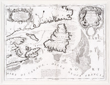
Canada Orientale nell' America Settentrionale: descritta dal P. Mro. Coronelli M C Cosmografo…
Description: Rectangular map, black on white paper. The map shows Newfoundland; Prince Edward Island; Anticosti Island; Cape Breton; part of mainland Nova Scotia; part of New Brunswick; part of Quebec; and part… more
Province: Newfoundland, Nova Scotia, Prince Edward Island
Type: topographic maps
Date Created: 1695
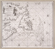
Pas-kaart, Vande Zee-Kusten van, Terra Nova, Met de Byleggende Zee-Kusten van Francia Nova Canada…
Description: Rectangular engraved map of Newfoundland, Nova Scotia, Prince Edward Island, and part of Quebec; framed and covered with glass. Black and white. Depicts Newfoundland, Nova Scotia, Cape Breton, Prince… more
Province: Newfoundland, Nova Scotia, Prince Edward Island, Quebec
Type: topographic maps
Date Created: 1687