Displaying 1 - 9 of 9

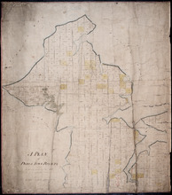
Plan of the Royalty of Charlottetown: from a survey taken in the year 1831 by Order of His…
Description: "Plan of the Royalty of Charlottetown from a survey taken in the year 1831 by Order of His Excellency Lieutenant Governor Ready." Shows Royalty Lot numbers, and acreage. (No.67) more
Province: Prince Edward Island
Type: cadastral maps
Date Created: 1831

Plan of Charlotte Town Shewing the true position of the Streets and the encroachments thereon.…
Description: The map shows the street grid, numbered town lots and public squares of Charlottetown. It shows some buildings and some of the roads leading to/from the town.
Province: Prince Edward Island
Type: plans
Date Created: 1833
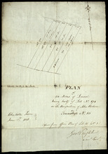
A Plan of Prince Town Royalty: from A Survey made in Nov. 1828
Description: A plan of Prince Town Royalty. Also shows Prince Town. Gives numbers of Town and Royalty Lots. The map shows bodies of water, squares, and towns.
Province: Prince Edward Island
Type: cadastral maps
Date Created: 1828-11

Plan of Township No. 16 in Prince Edward Island: The Estate of Laurence Sulivan Esq., Dept. Sect.…
Description: Plan of Lot 16, the estate of Lawrence Sullivan, Esq. Copied by Geo. Wright from a plan by James(?).
Province: Prince Edward Island
Type: cadastral maps
Date Created: 1851
Plan of the Division Line between Queens and Prince Counties & the Southern Boundary of…
Description: Plan of the division line between Queens and Prince Counties and the southern boundary of Lot 25 established by the Commissioners under the Boundary Line Act. Certified copy by G. Wright of 1835 plan… more
Province: Prince Edward Island
Type: boundary maps
Date Created: 1850
Plan of the Line dividing Kings and Queens Counties in Prince Edward Island as established by the…
Description: Plan of the line dividing Kings and Queens Counties in Prince Edward Island as established by the Commissioners under the provisions of the Act 4th: William 4th: Cap. 15 (No. 80). The map shows the… more
Province: Prince Edward Island
Type: boundary maps
Date Created: 1835

Plan of Township No. 67 in Prince Edward Island: The Property of Lady Wood
Description: Plan of Lot 67 (No.180). The property of Lady Wood. Shows names of residents, acreage, and some land conveyance references and a compass pointing North.
Province: Prince Edward Island
Type: cadastral maps
Date Created: 1858
Plan of 50 Acres of Land being half of Lot No. 171 in the Occupation of John Rechore in Township No…
Description: Plan of part of Lot 15. 50 acres of land, part of 171 in the occupation of John Rechore. Also shows (sub) lots 170, 172, 173 and 174. Copied from office plan of Lot 15. (No.3)
Province: Prince Edward Island
Type: cadastral maps
Date Created: 1851-06-03
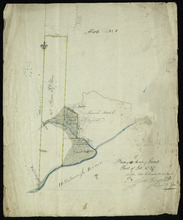
Plan of 150 Acres of Land Part of Lot No. 37.
Description: Plan of part of Lot 37 (No. 8). 150 acres of land, the property of John Stowe. The map shows a parcel of land, approximately 150 acres in size, outlined in yellow, on the north side of the… more
Province: Prince Edward Island
Type: cadastral maps