Displaying 1 - 14 of 14
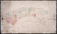
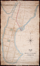
Plan of Cascumpec Point As sold by Public Auction in June 1871
Description: Plan of Cascumpec Point, as sold by public auction, June, 1871. The map shows lots, residents, bodies of water such as bays, cities and towns, and roads.
Province: Prince Edward Island
Type: cadastral maps
Date Created: 1871-08

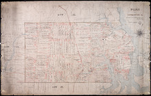
Plan of Town Lots at Cascumpec Point. Township No. 5.: Compiled and corrected from Surveys by John…
Description: Plan of Town Lots at Cascumpec Point, Lot 5. The map shows Cascumpec Point divided into parcels of land (most of them numbered) with names of residents. Shows land belonging to J. C. Pope outlined in… more
Province: Prince Edward Island
Type: cadastral maps
Date Created: 1877-08-01

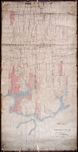
Plan of Cascumpec Point Copied from a Plan in the Public Lands Departt. furnished by John Ball. L.…
Description: Plan of Cascumpec Point, Lot 5. The map shows numbered parcels of land on Cascumpec Point with names of residents and some land conveyance references. The legend indicates that parcels are outlined… more
Province: Prince Edward Island
Type: cadastral maps
Date Created: 1885-06
Plan Showing the Situation of Joseph Hammil's Farm on Lot No. 2. Containing Thirty acres on…
Description: Plan of part of Lot 2 showing Joseph Hammill's Farm containing 30 acres. The map shows Joseph Hammill's 30-acre parcel shaded in a greenish colour. It also shows the adjacent parcel of John… more
Province: PE
Type: cadastral maps
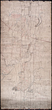
Plan of Township No. 12: Copied from Survey by John Ball L.S. by Thos Mackinlay
Description: Plan of Lot 12 (No.34). Stewart Estate. Copied from survey of John Ball by Thos. MacKinlay. Shows names of residents, acreage, and land conveyance references. The map shows bodies of water, Lennox (… more
Province: Prince Edward Island
Type: cadastral maps
Plan of Township No. 12
Description: Plan of Lot 12 (No.33). Stewart Estate. Shows names of residents and some acreage and land conveyance references. The map shows bodies of water, roads, a railroad station, and Lennox Island.
Province: Prince Edward Island
Type: cadastral maps
Plan of Township Number 10. Surveyed by John Ball, L. S.
Description: Plan of Lot 10 (No.28). Stewart Estate. Shows names of residents, acreage, and a few land conveyance references, bodies of water such as rivers, lakes, bays, and creeks, roads, and Bird Island.
Province: Prince Edward Island
Type: cadastral maps
Plan of Town Lots at Cascumpec Point. Township No. 5.: Compiled and corrected from Surveys by John…
Description: Plan of Town Lots at Cascumpec Point, Lot 5. The map shows Cascumpec Point divided into parcels of land (most of them numbered) with names of residents. Shows land belonging to J. C. Pope outlined in… more
Province: Prince Edward Island
Type: cadastral maps
Date Created: 1877-08-01

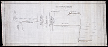
Plan of a proposed new line of road from Middleton Road to Isaac Ive's Millas coloured brown…
Description: Plan of a proposed new line of road from Middleton Road to Isaac Ive's Mill connecting with the road already opened from Searletown to Ive's Mill thro. part of Lot 27. The map shows lots,… more
Province: Prince Edward Island
Type: cadastral maps
Plan of a new line of road from Victoria West to Western Road Lot 13 Prince Co. P.E.Island
Description: Plan of a new line of road from Victoria West to Western Road. Lot 13. The map shows lots, residents, roads, and rivers.
Province: Prince Edward Island
Type: cadastral maps
Paln No. 1 of Railway Appropriation: from Alberton to Tignish
Description: Plan of Railway Appropriations from Alberton to Tignish. (Plan No.1). The map shows roads, resdients, acreage, lots, and foliage.
Province: Prince Edward Island
Type: cadastral maps
Date Created: 1873
Plan No. 2 of Railway Appopriation: From Alberton to Tignish
Description: Plan of Railway Appropriations from Alberton to Tignish. (Plan No.2). The map shows roads, lots, residents, acreage, and foliage.
Province: Prince Edward Island
Type: cadastral maps
Date Created: 1873

Plan of Alberton: Surveyed by John Ball, Land Surveyor
Description: Plan of part of Alberton, Lot 4. Shows names of residents and land conveyance references, bodies of water such as bays, and creeks, and roads.
Province: Prince Edward Island
Type: cadastral maps
Date Created: 1871-08

Plan of Township No. 2: Compiled from the Proprietors Plans and partial surveys
Description: Plan of Lot 2 (No.5). Compiled from the Proprietors Plans and partial surveys by John Ball, Public Lands Department. Cunard Estate. Shows the names of residents, former occupants, and land conveyance… more
Province: Prince Edward Island
Type: cadastral maps
Date Created: 1885-10