Displaying 1 - 2 of 2
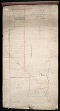
A Plan of the North or C Division of Lot or Township No. 59: Kings County, P. E. Island
Description: A plan of the north division of Lot 59 (No.159). James Montgomery Estate. The map shows the C Division of Lot 59 divided into numbered parcels of land with the names of occupants and their… more
Province: Prince Edward Island
Type: cadastral maps

Montague Bridge P.E.I.
Description: This is a fire insurance plan of the village of Montague Bridge consisting of two (2) maps--one for each side of the Montague River. It was created in 1888 and revised to 1910. The map on the left… more
Publisher: Chas. E. Goad, Civil Engineer
Province: Prince Edward Island
Type: fire insurance maps
Date Created: 1888-10
Date Modified: 1910-09
Date Issued (Source): 1888