Displaying 1 - 2 of 2

Lot No. 46
Description: Plan of Lot 46 (No.1) divided into two parts and drawn for in Council, Oct. 24, 1786. The map shows Lot 46 divided into two parts--Division No. 1 (west) and Division No. 2 (east)--of 10,000 acres… more
Province: Prince Edward Island
Type: cadastral maps
Date Created: 1786-10-24
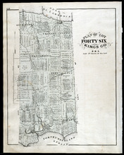
Plan of Lot Fourty Six: Kings Co., P.E.I.
Description: The map shows lot 46 in Kings county. Shown are a gulf, straits, pond, roads, landowners and acreage, school houses, post offices, mills, and sand. Compass.
Publisher: J. H. Meacham & company
Province: Prince Edward Island
Type: cadastral maps
Date Issued (Source): 1880