Displaying 1 - 9 of 9

Plan of George Town: The Town Lots are 84 by 120 Feet. The North and South Streets are 100 Feet.…
Description: Plan of Georgetown showing lots and streets, bays, ranges, squares, and a school house. Also shows location of school house. Copy from the Office Plan No.6.
Province: Prince Edward Island
Date Created: 1853-06-07
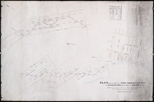
Plan Shewing Lands in the Town, Common, and Royalty of Georgetown appropriated for Railway purposes…
Description: Plan showing lands in the Town, Common, and Royalty of Georgetown appropriated for Railway Purposes. The map shows residents, acreage, roads, and harbours.
Province: Prince Edward Island
Type: cadastral maps
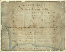
Plan of George-Town: Capital of Kings County, Prince Edward Island
Description: A hand-drawn map of Georgetown, PEI that includes the layout of the town including Kent Square, the ranges, house lots, water lots, and buildings. Three Rivers borders the town.
Province: Prince Edward Island
Date Created: 1835

Tracing of the right of way for the Prince Edward Island Railway into Georgetown.
Description: Tracing of the right of way for the Prince Edward Island Railway into Georgetown.
Province: Prince Edward Island
Type: cadastral maps

Plan of Georgetown, Georgetown Common, and Georgetown Royalty
Description: Plan of Georgetown, Georgetown Common, and Georgetown Royalty. Shows lot numbers. Gives names of a few residents in the Royalty. Also gives nautical soundings for Albion Bay and Brudenell River.
Province: Prince Edward Island
Type: cadastral maps
Date Created: 1828
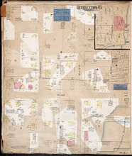
Georgetown P.E.I.
Description: This is the first of two pages of fire insurance maps of Georgetown. It was created in 1888, revised to 1897, and revised again to 1910. This page concentrates on an area one and a half blocks west… more
Publisher: Chas. E. Goad, Civil Engineer
Province: Prince Edward Island
Type: fire insurance maps
Date Created: 1888-10
Date Modified: 1897-11, 1910-09
Date Issued (Source): 1888
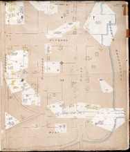
Georgetown P.E.I.: Oct. 1893
Description: This is the second of two (2) pages of fire insurance maps of Georgetown. It was created in 1893 and revised to 1910. The map concentrates on an area one and a half blocks east from West Street,… more
Publisher: Chas. E. Goad, Civil Engineer
Province: Prince Edward Island
Type: fire insurance maps
Date Created: 1893-10
Date Modified: 1910-09
Date Issued (Source): 1888
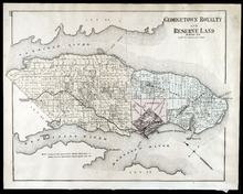
Georgetown Royalty and Reserve Land: Kings Co., P.E.I.
Description: The map shows Georgetown Royalty and Reserve Land in Kings county. Shown are rivers, roads, railroads and stations, landowners and acreage, beaches, Georgetown commons, square, market, court house,… more
Publisher: J. H. Meacham & company
Province: Prince Edward Island
Type: cadastral maps
Date Issued (Source): 1880
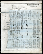
Georgetown: Kings Co., P.E.I.
Description: The map shows Georgetown in Kings county. Shown are wharfs, harbour, roads and streets, railroads and stations, landowners, houses, court house, scholl house, drill shed, Georgetown square, churches… more
Publisher: J. H. Meacham & company
Province: Prince Edward Island
Type: cadastral maps
Date Issued (Source): 1880