Displaying 1 - 4 of 4
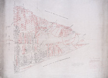
Plan of Township No. 47 in Prince Edward Island: compiled from the old plans and surveys on file in…
Description: The map, which appears to be incomplete, shows Lot 47 divided into parcels of land with names of residents, acreage amounts and land conveyance references. The map shows roads, rivers, streams and… more
Province: Prince Edward Island
Type: cadastral maps
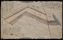
Plan of part of Lot 47: The Estate of the late Alexander McDonald showing allotments pursuant to…
Description: Plan of part of Lot 47. The estate of the late Alexander McDonald showing allotments pursuant to Order of Supreme Court Schedule G. The map shows the estate of the late Alexander McDonald divided… more
Province: Prince Edward Island
Type: cadastral maps
Date Created: 1885-07-07
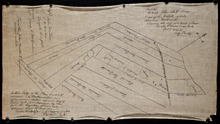
Plan of part of Lot 47: The estate of the late Alexander McDonald showing the different kinds of…
Description: Plan of part of Lot 47. The estate of the late Alexander McDonald showing the different kinds of land. Schedule F. The map, drawn in black ink, shows the estate of the late Alexander McDonald divided… more
Province: Prince Edward Island
Type: cadastral maps
Date Created: 1885-07-07
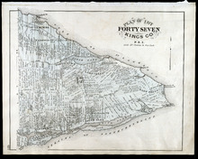
Plan of Lot Forty Seven: Kings Co., P.E.I.
Description: The map shows Lot 47 in Kings county. Shown are a gulf, straits, rivers, lakes, swamp, sand, fishing huts, mills, post offices, churches, creeks, light house, and pond. Compass.
Publisher: J. H. Meacham & company
Province: Prince Edward Island
Type: cadastral maps
Date Issued (Source): 1880