Displaying 1 - 3 of 3

Plan showing the situation of the line of road from Melville Road to Appin Road also the connecting…
Description: Plan showing the situation of the line of road from Melville Road to Appin Road; also, the connecting road leading to Crapaud Wharf. Roads pass through Lots 29 and 30. (No.15, Queen's). Shown… more
Province: Prince Edward Island
Type: cadastral maps
Date Created: 1868-06-08

Plan of Township No. 29: embracing the Fane and Melville Estates – 1883
Description: Plan of Lot 29 (No.80). Fane and Melville Estates.
Province: Prince Edward Island
Type: cadastral maps
Date Created: 1883
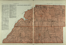
Lots 29 and 30: Queens County
Description: The map shows lots 29 and 30 in Queens county. Shown are roads, landowners, acreage, the Northumberland Strait, Westmoreland Harbour, and Sable River.
Publisher: Cummins Map Co.
Province: Prince Edward Island
Type: cadastral maps
Date Issued (Source): 1927