Displaying 1 - 5 of 5

Plan showing the situation of the line of road from Melville Road to Appin Road also the connecting…
Description: Plan showing the situation of the line of road from Melville Road to Appin Road; also, the connecting road leading to Crapaud Wharf. Roads pass through Lots 29 and 30. (No.15, Queen's). Shown… more
Province: Prince Edward Island
Type: cadastral maps
Date Created: 1868-06-08

Plan of Township No. 29: embracing the Fane and Melville Estates – 1883
Description: Plan of Lot 29 (No.80). Fane and Melville Estates.
Province: Prince Edward Island
Type: cadastral maps
Date Created: 1883
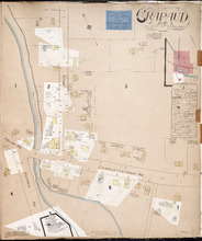
Crapaud P.E.I.: Population 300. No Appliances. Novr. 1897.
Description: This is a fire insurance plan of the village of Crapaud. It was created in 1897 and revised to 1910. The main map shows Main Street and the area where the roads into town converge. The Crapaud… more
Publisher: Chas. E. Goad, Civil Engineer
Province: Prince Edward Island
Type: fire insurance maps
Date Created: 1897-11
Date Modified: 1910-10
Date Issued (Source): 1888
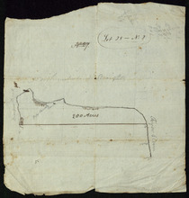
Lot 28 -- No. 2
Description: Plan of part of Lot 28 (No.2). The map shows 200 acres of land along the Northumberland Strait between Crapuad Creek and the Tryon River in Lot 28. Areas that appear to be marshes are indicated with… more
Province: Prince Edward Island
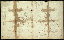
Entrance to the Croppo River
Description: Plan of part of Lot 29 (No.4). Entrance to Croppo River. Shows soundings at Crapaud Harbour. The map shows the harbour and entrance to the Crapaud (or Westmoreland) River. Soundings appear to be… more
Province: Prince Edward Island