Displaying 55 - 61 of 61
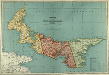
Province of Prince Edward Island, Canada: Cummins Map Co. Toronto
Description: The map shows all of Prince Edward Island and some of New Brunswick and Nova Scotia. Shown through a table of Counties are bays, roads, marshes, rapids, Indian Reserves, Lighthouses, depth of water,… more
Publisher: Cummins Map Co.
Province: Prince Edward Island
Type: cadastral maps
Date Issued (Source): 1927
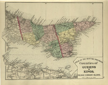
Counties of Queens and Kings: Prince Edward Island
Description: The map shows the counties of Queens and Kings in Prince Edward Island. Shown are bays, points, rivers, capes, coves, harbours, roads, railroads, cities, and towns.
Publisher: Roe Brothers
Province: Prince Edward Island
Type: geological maps
Date Issued (Source): 1878
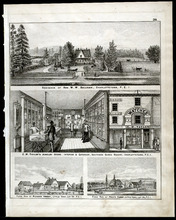
Property Sketches - Page 38
Description: Property sketches of the Residence of Hon. W. W. Sullivan, Charlottetown, P.E.I.; E.W. Taylor' Jewelry Store - interior and exterior, South Side Queen Square, Charlottetown, P.E.I.; The farms of… more
Publisher: J. H. Meacham & company
Province: Prince Edward Island
Type: image
Date Issued (Source): 1880
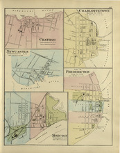
Chatham : Charlottetown : New Castle : City of Fredricton : Moncton: Northumberland Co. N.B..…
Description: The map shows Catham in the Northumberland county. New Brunswick. Shown are a river, wharf, streets, buildings, lots and a ferry crossing. The map shows Charlottetown in Queens county, Prince Edward… more
Publisher: Roe Brothers
Province: New Brunswick, Prince Edward Island
Type: geographical maps
Date Issued (Source): 1878
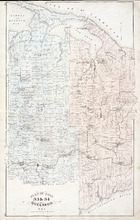
Plan of Lots 33 & 34: Queens Co., P.E.I.
Description: The map shows lots 33 (coloured in blue) & 34 (coloured in pink) in Queens county. The map shows roads, railroads and stations, landowners and acreage, farms, post offices, churches, hotels,… more
Publisher: J. H. Meacham & company
Province: Prince Edward Island
Type: cadastral maps
Date Issued (Source): 1880
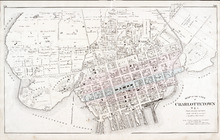
Map of the City of Charlottetown
Description: The map shows the city of Charlottetown. Shown are the wards, roads, landowners and acreage, asylums, ponds, rivers, houses, cemetery, estates, churches, lakes, parks, wharfs, and Charlottetown… more
Publisher: J. H. Meacham & company
Province: Prince Edward Island
Type: cadastral maps
Date Issued (Source): 1880
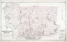
Plan of Charlottetown Royalty: Queens Co., P.E.I.
Description: The map shows the city of Charlottetown and a plan for lots. Shown are rivers, creeks, roads, railroad and stations, landowners and acreage, mills, park, bridge, college, farms, asylums, and a… more
Publisher: J. H. Meacham & company
Province: Prince Edward Island
Type: cadastral maps
Date Issued (Source): 1880