Displaying 1 - 4 of 4

Plan of the Western Portion of Township No. 65: containing 5250 acres and belonging to Mrs. Lydia…
Description: Plan of the western portion of Lot 65 (No.173). Estate of Mrs Lydia Wright. Roads, leased land[?] and freehold land on the Estate of Mrs. Lydia Wright. Tenant names appear on the sub-lots, which are… more
Province: Prince Edward Island
Type: cadastral maps
Date Created: 1841
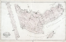
Lot 65: Queens County
Description: The map shows Lot 65 in Queens County. Shown are the Northumberland Strait, Hillsborough Bay, Elliott River, roads, landowners, acreage, and towns.
Publisher: Cummins Map Co.
Province: Prince Edward Island
Type: cadastral maps
Date Issued (Source): 1927
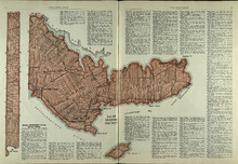
Plan of Lot 65 : Queens Co., P.E.I.
Description: The map shows Lot 65 in Queens county. Shown are roads, landowners and acreage, creeks, rivers, straits, marshes, brooks, coves, sand, reef, fishing stage, wharfs, post offices, mills, churches,… more
Publisher: J. H. Meacham & company
Province: Prince Edward Island
Type: cadastral maps
Date Issued (Source): 1880