| Title Proper |
Illustrated historical atlas of the province of Prince Edward Island
|
|---|---|
| Subtitle |
From surveys made under the direction of C. R. Allen
|
| Description |
Published in 1880 by the J. H. Meacham Company, the Illustrated Historical Atlas of the Province of Prince Edward Island contains maps of each Lot on the Island, maps of Charlottetown and various towns and villages, and engravings of prominent citizens, properties and businesses. The maps are based on surveys made under the direction of C. R. Allen, C.E.
Included in this atlas is a Historical Sketch of the Province of Prince Edward Island and a Patron's Directory. The Historical Sketch covers the history of the Island from the first settlements and treaties to governance and Confederation. The Patron's Directory, located at the back of the atlas, gives biographical information about principal businessmen and professionals across the Island. This directory includes information such as their profession, nativity, and date of settlement. |
| Access Condition |
This material is provided for research, education, and private use only.
|
| Type | |
| Physical Location |
Robertson Library, UPEI
|
| Contributors |
Creator: Allen, C. R.
|
| Date Issued |
1880
|
| Publisher |
J. H. Meacham & company
|
| Extent |
12, 15-162 p. : ill.
|
| Subject (Geographic) | |
| Subject (Topical) |
Illustrated historical atlas of the province of Prince Edward Island: From surveys made under the direction of C. R. Allen
In this collection
Displaying 1 - 27 of 147

Title Page
Description: Title page for the "Illustrated Historical Atlas of the province of Prince Edward Island From Surveys made under the direction of C. R. Allen, C.E." by J. H. Meacham more
Type: image
Date of Part: 1880
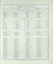
Table of Contents
Description: Table of Contents including the headings City, Town, and Village Maps, Lot and Royalty Maps, Portraits, and Views.
Type: text
Date of Part: 1880
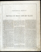
Historical Sketch of the Province of Prince Edward Island - Page 3
Description: The beginning of The Historical Sketch of Prince Edward Island, which cover such topics as Geographical Position, Discovery and Early Settlement, the Treaty of Utrecht, and French and English… more
Province: Prince Edward Island
Type: text
Date Issued (Source): 1880

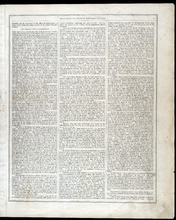
Historical Sketch of the Province of Prince Edward Island - Page 4
Description: This portion of the historical sketch of P.E.I. includes information on various topics such as The Population of the Island, The Treaty of Fontainbleau and a list of lot owners, The Quit Rents,… more
Province: Prince Edward Island
Type: text
Date Issued (Source): 1880
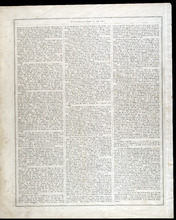
Historical Sketch of the Province of Prince Edward Island - Page 5
Description: This portion of the historical sketch of P.E.I. includes information on various topics such as The American War of Independence, Governors of the Island (Patterson, Fanning, Smith) and their… more
Province: Prince Edward Island
Type: text
Date Issued (Source): 1880
Historical Sketch of the Province of Prince Edward Island - Page 6
Description: This portion of the historical sketch of P.E.I. includes information on various topics such as Governors (Ready, Young, Huntley, Campbell, Bannerman), progress and population growth, the crowning of… more
Province: Prince Edward Island
Type: text
Date Issued (Source): 1880
Historical Sketch of the Province of Prince Edward Island - Page 7
Description: This portion of the historical sketch of P.E.I. includes information on various topics such as the Telegraph Cable between Cape Tormentine and Cape Traverse, treaties with the United States,… more
Province: Prince Edward Island
Type: text
Date Issued (Source): 1880
Historical Sketch of the Province of Prince Edward Island - Page 8
Description: This portion of the historical sketch of P.E.I. includes information various topics such as Island Government, Confederation, the Tenant League, and the American Civil War (continued on page 9).
Province: Prince Edward Island
Type: text
Date Issued (Source): 1880
Historical Sketch of the Province of Prince Edward Island - Page 9
Description: This portion of the historical sketch of P.E.I. includes information regarding the Fenian Organization, Confederation, dealings with the United States, legislature, the telegraph, the Governor… more
Province: Prince Edward Island
Type: text
Date Issued (Source): 1880
Historical Sketch of the Province of Prince Edward Island - Page 10
Description: This portion of the historical sketch of P.E.I. includes information under such subtitles as The Railroad Question and On the First Day of July, 1873. This page also includes information on the… more
Province: Prince Edward Island
Type: text
Date Issued (Source): 1880
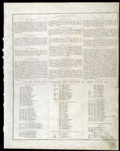
Historical Sketch of the Province of Prince Edward Island - Page 11
Description: This portion of the historical sketch of P.E.I. includes information on the histories and populations of Lots 5 through 67, as well as information about the towns of Charlottetown, Georgetown, and… more
Province: Prince Edward Island
Type: text
Date Issued (Source): 1880
Biographical Sketches - Page 12
Description: Biographical sketches of the Hon. William Wilfred Sullivan Q.C., Hon. Neil McLeod, Hon. Donald Ferguson, Hon. Samuel Prowse, Hon. Joseph Wightman, Caleb Schurman Esq., Alfred McWilliams, Esq.,… more
Province: Prince Edward Island
Type: text
Date Issued (Source): 1880
Biographical Sketches - Page 13
Description: Biographical sketches of John C. Leitch Esq., George Mutch Esq., Duncan Munn Esq., Malcolm McFadyen Esq., Hon. Lauchlin McMillan, Alexander Anderson Esq., Geo. Mason Esq., Benjamin Wright Esq., John… more
Province: Prince Edward Island
Type: text
Date Issued (Source): 1880
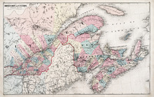
Dominion of Canada: (Eastern Sheet)
Description: Map showing the province of Quebec, New Brunswick, Nova Scotia, and Prince Edward Island. Shows rivers, lakes, channels, bays, roads, railroads, cities, and towns. The provinces and cities are tinted… more
Province: Quebec, New Brunswick, Nova Scotia, Prince Edward Island
Type: pictorial maps
Date Issued (Source): 1880
Dominion of Canada: (Western Sheet)
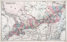
Description: Map showing the province of Ontario, and Quebec. Shows rivers, lakes, channels, bays, roads, railroads, cities, towns, copper mines, and sea measurements. Ontario and Quebec are coloured and cities… more
Province: Ontario, Quebec, Prince Edward Island, Michigan, New York, Ohio
Type: cadastral maps
Date Issued (Source): 1880
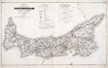
Map of the Province of Prince Edward Island: in the Gulf of St. Lawrence
Description: The map shows the province of Prince Edward Island. Shown are tables of Explanations and Electorial Districts, a compass and the county lines are marked in red. Shown are gulfs, straits, bays, reefs… more
Province: Prince Edward Island
Type: cadastral maps
Date Created: 1880
Date Issued (Source): 1880

Plan of Lot One: Prince Co., P.E.I.
Description: Map showing the northWestern tip of the island. It names the gulfs, rivers, ponds, landowners and acreage, roads, and railroads. A graphic compass.
Province: Prince Edward Island
Type: cadastral maps
Date Issued (Source): 1880

Plan of Lot Six: Prince Co., P.E.I.
Description: Map showing lot six, bordering lots 5, 9, 10, 11 in Prince county. Shows rivers, creeks, railroads, roads, landowners, acreage, post offices, and buildings. Geographical compass
Province: Prince Edward Island
Type: cadastral maps
Date Issued (Source): 1880

Plan of Lots Two : Prince Co., P.E.I.
Description: Map showing lots 2
Province: Prince Edward Island
Type: cadastral maps
Date Issued (Source): 1880

Plan of Lot Seven: Prince Co., P.E.I.
Description: Map showing lot seven, bordering lots 4, 5, 6, and 8 in Prince county. Shows gulfs, railroads, roads, landowners, acreage, post offices, and buildings. Geographical compass
Province: Prince Edward Island
Type: cadastral maps
Date Issued (Source): 1880

Tignish, Prince Co.: Campbellton
Description: The map shows Lot 1 in Tignish, Prince county. Shown are roads, landowners and acreage, a church, chapel, and convent, a cemetery, railroad and station, grammar school, business, and houses. Compass.
Province: Prince Edward Island
Type: cadastral maps
Date Issued (Source): 1880
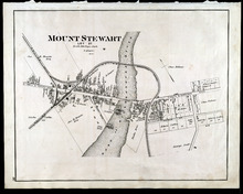
Mount Stewart: Lot 37
Description: The map shows lot 37 in Mount Stewart. Shown are roads, railroads and depot, landowners, houses, churches, Hillsborough river, wharfs, halls, and shipyard. Compass.
Province: Prince Edward Island
Type: cadastral maps
Date Issued (Source): 1880
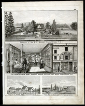
Property Sketches - Page 38
Description: Property sketches of the Residence of Hon. W. W. Sullivan, Charlottetown, P.E.I.; E.W. Taylor' Jewelry Store - interior and exterior, South Side Queen Square, Charlottetown, P.E.I.; The farms of… more
Province: Prince Edward Island
Type: image
Date Issued (Source): 1880

Plan of Lot Four : Prince Co., P.E.I.
Description: Map showing lots four
Province: Prince Edward Island
Type: cadastral maps
Date Issued (Source): 1880

Plan of Lot Eight: Prince Co., P.E.I.
Description: The map shows lot 8 in Prince county. Shown are roads, landowners and acreage, rivers, Northumberland strait, ponds, lighthouses, post offices, churches, mills, and businesses. Compass.
Province: Prince Edward Island
Type: cadastral maps
Date Issued (Source): 1880

Plan of Lot Thirteen: Prince Co., P.E.I.
Description: Map showing lot thirteen, bordering lots 12, 14 and 15, in Prince county. Shows gulfs, straits, bays, rivers, ponds, creeks, railroads, roads, landowners, acreage, post offices, and buildings.… more
Province: Prince Edward Island
Type: cadastral maps
Date Issued (Source): 1880

Plan of Lot Nine: Prince Co., P.E.I.
Description: The map shows lot 9 in Prince county. Shown are roads, landowners and acreage, Egmont bay, sand, Brae river, post offices, railroad and station, schools and churches. Compass.
Province: Prince Edward Island
Type: cadastral maps
Date Issued (Source): 1880