Displaying 811 - 837 of 992
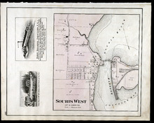
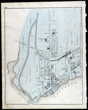
Souris West Lot 44: Kings Co., P.E.I.
Description: The map shows Lot 44 in Souris West, Kings county. Shown are a bay, harbour, river, railroad, landowners, roads, houses and buildings, school houses, businesses, and shipyards. Compass.
Publisher: J. H. Meacham & company
Province: Prince Edward Island
Type: cadastral maps
Date Issued: 1880
Date Issued (Source): 1880
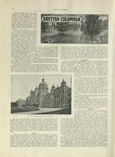
British Columbia - 1
Description: Text provides information of history, climate, lumbering, and agriculture in British Columbia
Publisher: Cummins Map Co.
Province: British Columbia
Type: text
Date Issued (Source): 1927
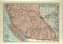
Province of British Columbia, Canada
Description: The map shows the province of British Columbia, Canada. Shown are the Pacific Ocean, Rocky Mountains, Vancouver Island, mountains, roads, and railroads.
Publisher: Cummins Map Co.
Province: British Columbia, Alberta
Type: cadastral maps
Date Issued (Source): 1927
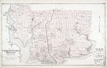
Plan of Charlottetown Royalty: Queens Co., P.E.I.
Description: The map shows the city of Charlottetown and a plan for lots. Shown are rivers, creeks, roads, railroad and stations, landowners and acreage, mills, park, bridge, college, farms, asylums, and a… more
Publisher: J. H. Meacham & company
Province: Prince Edward Island
Type: cadastral maps
Date Issued (Source): 1880
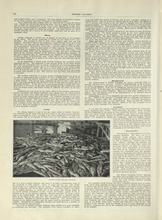
British Columbia - 2
Description: Text provides information of the population and the various industries in British Columbia, such as mining, fishing, manufacturing, and transportation.
Publisher: Cummins Map Co.
Province: British Columbia
Type: text
Date Issued (Source): 1927
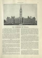
The Dominion of Canada - 1
Description: Text provides information of the history of Canada as a dominion and the establishment of the provinces and territories.
Publisher: Cummins Map Co.
Type: text
Date Issued (Source): 1927
The Dominion of Canada - 2
Description: Text provides information of the physical features of the land dividing each provinces and territories, and the industries that belong to each province and territory
Publisher: Cummins Map Co.
Province: Yukon, Northwest Territories
Type: text
Date Issued (Source): 1927
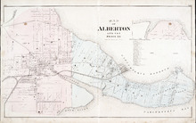
Map of Alberton Lots 4 & 5: Prince Co., P.E.I.
Description: The map shows lots 4 & 5 in the town of Alberton, Prince county. Shown are rivers, creeks, lakes, wharfs, shipyard, roads, railroad, landowners and acreage, mills, churches and cemetery. Compass… more
Publisher: J. H. Meacham & company
Province: Prince Edward Island
Type: cadastral maps
Date Issued (Source): 1880
Title Page - International Atlas
Description: The title page for the New International Atlas of the World
Publisher: Cummins Map Co.
Type: text
Date Issued (Source): 1927
Table of Contents - International Atlas
Description: The table of contents page that shows the list of countries and maps of countries and the page they are mentioned
Publisher: Cummins Map Co.
Type: text
Date Issued (Source): 1927
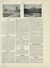
Europe - 1
Description: Text provides an introduction to Europe and gives the general history, population, climate, and notable industries of Austria, Belgium, the British Empire, and Bulgaria
Publisher: Cummins Map Co.
Type: text
Date Issued (Source): 1927
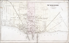
Summerside: Prince Co.
Description: The map shows the city of Summerside. Shown are the wards, roads, landowners and acreage, harbour, barracks, schools, squares, shipyards, railroad and station, and wharfs. Compass.
Publisher: J. H. Meacham & company
Province: Prince Edward Island
Type: cadastral maps
Date Issued (Source): 1880
Europe - 2
Description: Text provides information on the general history, population, climate, and notable industries of Czecho-Slovakia and Denmark
Publisher: Cummins Map Co.
Type: text
Date Issued (Source): 1927
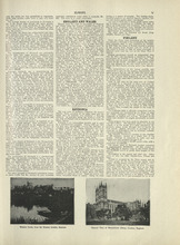
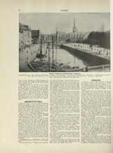
Europe - 3
Description: Text provides information on the general history, population, climate, and notable industries of England, Wales, Esthonia, and Finland
Publisher: Cummins Map Co.
Type: text
Date Issued (Source): 1927
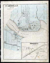
Cardigan Lot 53: Morrell Lot 40
Description: The map shows lot 53 in Cardigan. Shown are a river, roads, railroads, lots, landowners, school house, buildings, houses, wharfs and creeks. Compass.
Publisher: J. H. Meacham & company
Province: Prince Edward Island
Type: cadastral maps
Date Issued (Source): 1880
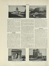
Europe - 4
Description: Text provides information on the general history, population, climate, and notable industries of France and Germany
Publisher: Cummins Map Co.
Type: text
Date Issued (Source): 1927

Montague Bridge Lots 59 & 52: Kings Co., P.E.I.
Description: The map shows lots 59 & 52 in Montague Bridge, Kings county. Shown are rivers, wharfs, shipyards, roads, landowners and acreage, halls, churches, buildings and businesses. Compass.
Publisher: J. H. Meacham & company
Province: Prince Edward Island
Type: cadastral maps
Date Issued (Source): 1880
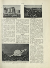
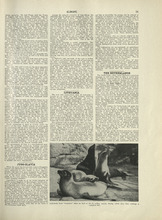
Europe - 5
Description: Text provides information on the general history, population, climate, and notable industries of Greece and Hungary
Publisher: Cummins Map Co.
Type: text
Date Issued (Source): 1927
Souris
Description: The map shows a part of Souris. Shown are the Souris river, sand beach, roads, railroads, churhces, landowners, houses, buildings and businesses. Compass
Publisher: J. H. Meacham & company
Province: Prince Edward Island
Type: cadastral maps
Date Issued (Source): 1880
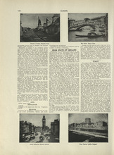
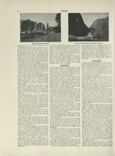
Europe - 6
Description: Text provides information on the general history, population, climate, and notable industries of Free State of Ireland, and Italy
Publisher: Cummins Map Co.
Type: text
Date Issued (Source): 1927
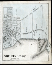
Souris East: Lot Forty Five
Description: The map shows Lot 45 in Souris East. Shown are the Souris Harbour and Bay, wharfs, roads and streets, railroads, lobster factory, landowners, houses, buildings and businesses. Compass
Publisher: J. H. Meacham & company
Province: Prince Edward Island
Type: cadastral maps
Date Issued (Source): 1880
Europe - 7
Description: Text provides information on the general history, population, climate, and notable industries of Jugo-Slavia, Lithuania, and the Netherlands
Publisher: Cummins Map Co.
Type: text
Date Issued (Source): 1927
Europe - 8
Description: Text provides information on the general history, population, climate, and notable industries of Norway and Poland
Publisher: Cummins Map Co.
Type: text
Date Issued (Source): 1927
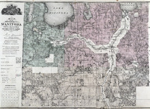
Map of the Province of Manitoba
Description: The map shows the province of Manitoba. Shown on the side are a Reference table and a Township diagram, lakes, roads, marshes, Indian Reserves, churches, rivers, and ponds. Compass.
Publisher: J. H. Meacham & company
Province: Manitoba
Type: cadastral maps
Date Issued (Source): 1880
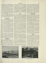
Europe - 9
Description: Text provides information on the general history, population, climate, and notable industries of Portugal, Romania, Russia, Scotland, and Spain
Publisher: Cummins Map Co.
Type: text
Date Issued (Source): 1927
Patron's Directory - Page 165
Description: Patron's Directory of the Province of Prince Edward Island. Giving names of the principal professional and business men in the city, towns, and villages, a description of their business, and of… more
Type: text
Date of Part: 1880

Europe - 10
Description: Text provides information on the general history, population, climate, and notable industries of Sweden, Switzerland, Ukraine, and the Minor European States (Andorra, the Channel Islands, Crete,… more
Publisher: Cummins Map Co.
Type: text
Date Issued (Source): 1927