Displaying 676 - 702 of 992
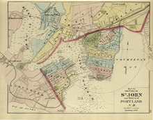
Map of the City of St. John and Town of Portland: N.B.
Description: The map shows the City of St. John and Town of Portland in New Brunswick. Shown are bays, rivers, harbour, lots, acreage, roads, railroads, towns, buildings, and names.
Publisher: Roe Brothers
Province: New Brunswick
Type: geological maps
Date Issued (Source): 1878
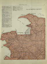
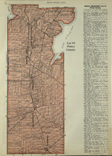
Lot 13, Lennox Island: Prince County
Description: The map shows Lot 13 in Prince county. Shown are bays, roads, creeks, and towns. Also shown in a smaller map at the top is Lennox Island. Shown there are landowners, peat bogs, and Gull, Salt Grass,… more
Publisher: Cummins Map Co.
Province: Prince Edward Island
Date Issued (Source): 1927
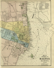
Map of the City of Halifax: Halifax Co. N.S.
Description: The map shows the city of Halifax, Halifax County in Nova Scotia. Shown are a Reference table, Halifax Harbour, pond, roads, wards, lots, buildings, and landowners.
Publisher: Roe Brothers
Province: Nova Scotia
Type: geographical maps
Date Issued (Source): 1878
Lot 15: Prince County
Description: The map shows lot 15 in Prince county. Shown are Red Head, Cape Egmont, Egmont Bay, the Northumberland Strait, rivers, landowners, acreage, and roads.
Publisher: Cummins Map Co.
Province: Prince Edward Island
Type: cadastral maps
Date Issued (Source): 1927

Plan of Lot Eight: Prince Co., P.E.I.
Description: The map shows lot 8 in Prince county. Shown are roads, landowners and acreage, rivers, Northumberland strait, ponds, lighthouses, post offices, churches, mills, and businesses. Compass.
Publisher: J. H. Meacham & company
Province: Prince Edward Island
Type: cadastral maps
Date Issued (Source): 1880
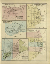
Chatham : Charlottetown : New Castle : City of Fredricton : Moncton: Northumberland Co. N.B..…
Description: The map shows Catham in the Northumberland county. New Brunswick. Shown are a river, wharf, streets, buildings, lots and a ferry crossing. The map shows Charlottetown in Queens county, Prince Edward… more
Publisher: Roe Brothers
Province: New Brunswick, Prince Edward Island
Type: geographical maps
Date Issued (Source): 1878
Lots 14 and 16 : Prince County
Description: The map shows lots 14 and 16, in Prince county. Shown are bays, ponds, coves, landowners, acreage, rivers, and roads.
Publisher: Cummins Map Co.
Province: Prince Edward Island
Type: cadastral maps
Date Issued (Source): 1927

Plan of Lot Thirteen: Prince Co., P.E.I.
Description: Map showing lot thirteen, bordering lots 12, 14 and 15, in Prince county. Shows gulfs, straits, bays, rivers, ponds, creeks, railroads, roads, landowners, acreage, post offices, and buildings.… more
Publisher: J. H. Meacham & company
Province: Prince Edward Island
Type: cadastral maps
Date Issued (Source): 1880
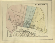
St. Stephen
Description: The map shows St. Stephen. Shown are a railroad and station, lots, wards, roads, buildings, and St. Croix River.
Publisher: Roe Brothers
Province: New Brunswick
Type: geographical maps
Date Issued (Source): 1878
Lot 17: Prince County
Description: The map shows Lot 17 in Prince county. Shown are byas, coves, landowners, acreage, towns, cities, and roads.
Publisher: Cummins Map Co.
Province: Prince Edward Island
Type: cadastral maps
Date Issued (Source): 1927

Plan of Lot Nine: Prince Co., P.E.I.
Description: The map shows lot 9 in Prince county. Shown are roads, landowners and acreage, Egmont bay, sand, Brae river, post offices, railroad and station, schools and churches. Compass.
Publisher: J. H. Meacham & company
Province: Prince Edward Island
Type: cadastral maps
Date Issued (Source): 1880
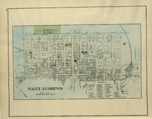
St. Andrews
Description: The map of St. Andrews. Shown are a Reference table, railroads and station, military lands, roads, lots, owners, and wharfs.
Publisher: Roe Brothers
Province: New Brunswick
Type: geographical maps
Date Issued (Source): 1878
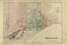
Moncton
Description: The map shows Moncton. Shown are a References table, wards, roads, railways and station, lots, buildings, landowners, and Petitcodiac River.
Publisher: Roe Brothers
Province: New Brunswick
Type: geographical maps
Date Issued (Source): 1878

Plan of Lot Fourteen & Sixteen : Prince Co., P.E.I.
Description: Map shows lots fourteen & sixteen in Prince county. Shown are roads, creeks, coves, rivers, post offices, railroads and stations, ferries, points, bays, landowners, acreage, churches, and… more
Publisher: J. H. Meacham & company
Province: Prince Edward Island
Type: cadastral maps
Date Issued (Source): 1880
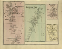
Hillsborough : Hopewell Cape : Salisbury : Hopewell Corner
Description: The map shows Hillsborough. Shown are buildings, lots, landowners, districts, Mill creek, wharfs, railways, post offices and shops. The map shows Hopewell Cape. Shown are buildings, landowners, roads… more
Publisher: Roe Brothers
Province: New Brunswick
Type: geographical maps
Date Issued (Source): 1878
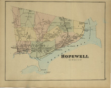
Hopewell
Description: The map shows Hopewell. Shown are a bay, island, rivers, wharf, railway and station, roads, landowners, and mountains.
Publisher: Roe Brothers
Province: New Brunswick
Type: geographical maps
Date Issued (Source): 1878

Plan of Lot Ten: Prince Co., P.E.I.
Description: The map shows lot 10 in Prince county. Shown are roads, rivers and creeks, railroad and station, post offices, a school, and landowners and acreage. Compass.
Publisher: J. H. Meacham & company
Province: Prince Edward Island
Type: cadastral maps
Date Issued (Source): 1880
Lots 25 & 26 : Prince County
Publisher: Cummins Map Co.
Type: cadastral maps
Date Issued (Source): 1927

Plan of Lot Seventeen: Prince Co., P.E.I.
Description: The map shows lot 17 along with two smaller maps of lot 17 and 23. The map includes landowners and acreage, railroads and stations, roads, districts, creeks, rivers, bays, marshes, brooks, coves,… more
Publisher: J. H. Meacham & company
Province: Prince Edward Island
Type: cadastral maps
Date Issued (Source): 1880
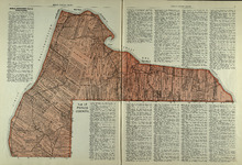
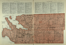
Lots 27 and 28: Prince County
Description: The map shows lots 27 and 28 in Prince county. Shown are the Northumberland Strait, points, coves, landowners, acreage, roads, and a railroad.
Publisher: Cummins Map Co.
Province: Prince Edward Island
Type: cadastral maps
Date Issued (Source): 1927
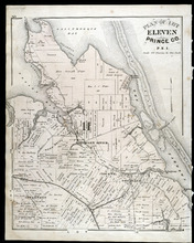
Plan of Lot Eleven: Prince Co., P.E.I.
Description: The map shows lot 11 in Prince county. Shown are roads, landowners and acreage, rivers, bays, coves, creeks, ponds, sand, railroad and station, post offices, and school houses. Compass.
Publisher: J. H. Meacham & company
Province: Prince Edward Island
Type: cadastral maps
Date Issued (Source): 1880
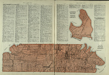
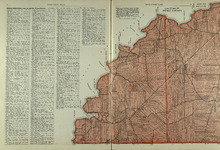
Rural Directory - Lots 27 and 28, Prince County and Lot 67, Queens county
Description: A directory listing of residents of lots 27 and 28 in Prince County and lot 67 in Queens County
Publisher: Cummins Map Co.
Province: Prince Edward Island
Type: text
Date Issued (Source): 1927
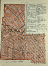
Lot No. 67: Queens County
Description: The map shows lot 67 in Queens county.Shown are roads, railroads, landowners, acreage, and Emerald Junction.
Publisher: Cummins Map Co.
Province: Prince Edward Island
Type: cadastral maps
Date Issued (Source): 1927