Displaying 838 - 864 of 992
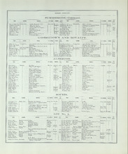
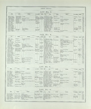
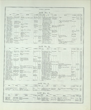
Patron's Directory - Page 166
Description: Patron's Directory of the Province of Prince Edward Island. Giving names of the principal professional and business men in the city, towns, and villages, a description of their business, and of… more
Type: text
Date of Part: 1880
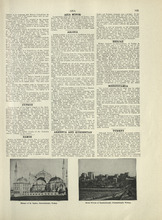
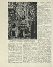
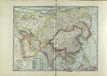
Asia - 1
Description: Text provides information on the general history, population, climate, and notable industries of Cyprus, Samos, Arabia, Armenia and Kurdestan, Hedjaz, Mesopotamia, and Turkey
Publisher: Cummins Map Co.
Type: text
Date Issued (Source): 1927
Patron's Directory - Page 167
Description: Patron's Directory of the Province of Prince Edward Island. Giving names of the principal professional and business men in the city, towns, and villages, a description of their business, and of… more
Type: text
Date of Part: 1880
Patron's Directory - Page 168
Description: Patron's Directory of the Province of Prince Edward Island. Giving names of the principal professional and business men in the city, towns, and villages, a description of their business, and of… more
Type: text
Date of Part: 1880
Asia - 3
Description: Text provides information on the general history, population, climate, and notable industries of Afghanistan and Persia.
Publisher: Cummins Map Co.
Type: text
Date Issued (Source): 1927
Patron's Directory - Page 169
Description: Patron's Directory of the Province of Prince Edward Island. Giving names of the principal professional and business men in the city, towns, and villages, a description of their business, and of… more
Type: text
Date of Part: 1880
Patron's Directory - Page 170
Description: Patron's Directory of the Province of Prince Edward Island. Giving names of the principal professional and business men in the city, towns, and villages, a description of their business, and of… more
Type: text
Date of Part: 1880
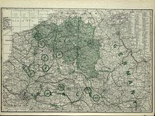
Western Battle Front
Description: The map shows the Western Battle Front in France, Belgium, and Germany. Shown are fortresses and fortified towns, forts, airship bases, wireless stations, railways, highways, and canals.
Publisher: Cummins Map Co.
Type: cadastral maps
Date Issued (Source): 1927
Patron's Directory - Page 171
Description: Patron's Directory of the Province of Prince Edward Island. Giving names of the principal professional and business men in the city, towns, and villages, a description of their business, and of… more
Type: text
Date of Part: 1880
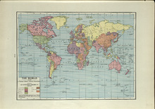
The World: Showing Principal Nations' Colonial Possessions
Description: The map shows the world and colonial possessions. Shown is a coloured table of the principal Nations' Colonial Possessions, countries, oceans and coordinates. more
Publisher: Cummins Map Co.
Type: cadastral maps
Date Issued (Source): 1927
Patron's Directory - Page 172
Description: Patron's Directory of the Province of Prince Edward Island. Giving names of the principal professional and business men in the city, towns, and villages, a description of their business, and of… more
Type: text
Date of Part: 1880
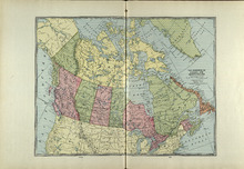
The Dominion of Canada and Newfoundland
Description: The map shows the dominion of Canada and Newfoundland. Shown are all provinces, territories, Greenland, and United States, oceans, bays, and mountains.
Publisher: Cummins Map Co.
Type: cadastral maps
Date Issued (Source): 1927
Patron's Directory - Page 173
Description: Patron's Directory of the Province of Prince Edward Island. Giving names of the principal professional and business men in the city, towns, and villages, a description of their business, and of… more
Type: text
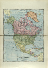
North America
Description: The map shows North America. Shown is the dominion of Canada, United States, Mexico, Central America, bodies of water, and coordinates.
Publisher: Cummins Map Co.
Type: cadastral maps
Date Issued (Source): 1927
Patron's Directory - Page 174
Description: Patron's Directory of the Province of Prince Edward Island. Giving names of the principal professional and business men in the city, towns, and villages, a description of their business, and of… more
Type: text
Date of Part: 1880
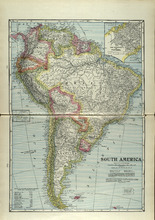
South America
Description: The map shows South America. Shown is a table of Political Divisions of South America with area and population, capitals of countries and states, railroads and telegraph lines, bodies of water,… more
Publisher: Cummins Map Co.
Type: cadastral maps
Date Issued (Source): 1927
Patron's Directory - Page 175
Description: Patron's Directory of the Province of Prince Edward Island. Giving names of the principal professional and business men in the city, towns, and villages, a description of their business, and of… more
Type: text
Date of Part: 1880
Patron's Directory - Page 176
Description: Patron's Directory of the Province of Prince Edward Island. Giving names of the principal professional and business men in the city, towns, and villages, a description of their business, and of… more
Type: text
Date of Part: 1880
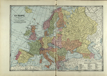
Europe
Description: The map shows the country of Eroupe. Shown are capitals of countries, railroads, submarine telegraph lines, a table of Principal Divisions of Europe, bodies of water, and coordinates.
Publisher: Cummins Map Co.
Type: cadastral maps
Date Issued (Source): 1927
Patron's Directory - Page 177
Description: Patron's Directory of the Province of Prince Edward Island. Giving names of the principal professional and business men in the city, towns, and villages, a description of their business, and of… more
Type: text
Date of Part: 1880
Patron's Directory - Page 178
Description: Patron's Directory of the Province of Prince Edward Island. Giving names of the principal professional and business men in the city, towns, and villages, a description of their business, and of… more
Type: text
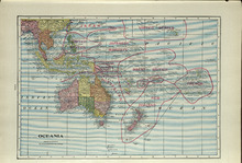
Oceania
Description: The map shows the Oceania. Shown are the Topic of Capricorn and the Equator lines, countries, great sand deserts, bodies of water, cities, and towns.
Publisher: Cummins Map Co.
Type: cadastral maps
Date Issued (Source): 1927
Patron's Directory - Page 179
Description: Patron's Directory of the Province of Prince Edward Island. Giving names of the principal professional and business men in the city, towns, and villages, a description of their business, and of… more
Type: text
Date of Part: 1880
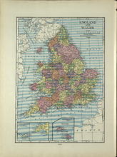
England and Wales
Description: The map shows England and Wales/ Shown are the North and Irish Sea, St. Patrick's, St. George's, Britol, and English Channel, cities and towns. more
Publisher: Cummins Map Co.
Type: cadastral maps
Date Issued (Source): 1927