Displaying 487 - 513 of 992

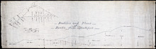
Plan of New Line Road from South Wiltshire Road Lot 31 to Emyvale Road Lot 65
Description: Plan of new line of road from South Wiltshire Road, Lot 31, to Emyvale Road, Lot 65. The map shows lots, roads, and residents.
Province: Prince Edward Island
Type: cadastral maps
Date Created: 1892-12-29
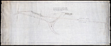
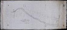
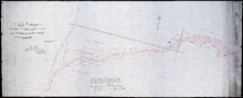
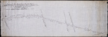
Profiles and plans of roads from Southport
Description: Profiles and plans of roads from Southport. (No.10) The map shows roads, lots, residents, and acreage.
Province: Prince Edward Island
Type: cadastral maps
Plan of proposed road from Winsloe Road to Brackley Point Road touching at Roy; Junc; Station
Description: Plan of proposed road from Winsloe Road to Brackley Point Road touching at Royalty Junction Station. Lot 33. (No.28) The map shows lots, roads, and residents.
Province: Prince Edward Island
Type: cadastral maps
Plan from French Village Road to Anderson Road
Description: Plan of road from French Village Road to Anderson Road. Lot 37. (No.8; also No.1 Queen's Co.) The map shows lots, roads, residents, and foliage. more
Province: Prince Edward Island
Type: cadastral maps
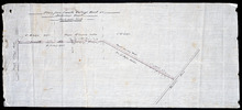
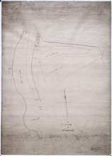
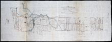
Section Shewing the Elevations of the Prince Toen Road from Hunter River to the Junction Road.
Description: Plan showing the elevations of the Prince Town Road from Hunter River to the Junction Road.
Province: Prince Edward Island
Type: cadastral maps
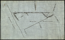
Plan Shewing the Malpeque Road from Charlottetown Royalty to Murrays: also the intended new line of…
Description: Plan Showing the Malpeque Road from Charlottetown Royalty to Murrays, also the intended new line of Road to avoid the Hills as Shown by the dotted line. Also are roads, lots, and bodies of water.
Province: Prince Edward Island
Type: cadastral maps

A Plan of Land on Lot or Township No. 17 in Prince County, P. E. Island
Description: A plan of part of Lot 17, the property of J. Weatherbe, Summerside. (No.11). Shown are lots, residents, measurements and roads.
Province: Prince Edward Island
Type: cadastral maps
Date Created: 1857-06

Plan of A Tract of Land situate in Summerside P.E.Island, in the possesion of Mr. Jesse Green, laid…
Description: Plan of a tract of land situated in Summerside and laid off in pasture lots. The property of Mr. Jesse Green. The map shows lots, residents, roads, and acreage.
Province: Prince Edward Island
Type: cadastral maps
Date Created: 1877-04-24
Plan of part of Lot 28, showing the property of William Carruthers bordering on Borden Harbour.
Description: Plan of part of Lot 28, showing the property of William Carruthers bordering on Borden Harbour. The map shows lots, residents, water, and roads.
Province: Prince Edward Island
Type: cadastral maps

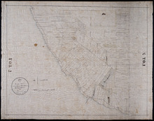
Plan of Town Lots No.74 and No.75 in the 4th Hundred of Town Lots in the city of Charlottetown with…
Description: Plan of Town Lots No.74 and No.75 in the 4th Hundred of Town Lots in the city of Charlottetown with the respective subdivisions delineated thereon. (No.64) Shown are lots and residents.
Province: Prince Edward Island
Type: cadastral maps
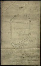
Plan of Race Course Charlottetown Royalty
Description: Plan of the Old Race Course in Charlottetown Royalty. (No.21). Shows lots and residents.
Province: Prince Edward Island
Type: cadastral maps

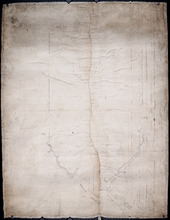
Plan of Lot 5: Mainly Outline
Description: Plan of Lot 5. Mainly outline. Shows names of some residents east of Mill River, lots, and waters.
Province: Prince Edward Island
Type: cadastral maps
Plan of New Line Road From Montague Bridge tp Keith's Mill on Lots No. 51 & 52: Kings…
Description: Plan of a new line of road from Montague Bridge to Keith's Mill on Lots 51 and 52. As ordered by Jas. E. McDonald, late C.P.W. The map shows lots, residents, roads, and bodies of water such as… more
Province: Prince Edward Island
Type: cadastral maps
Copy of a plan made by Alexander Anderson in 1845 of that portion of the northern part of Lot 11…
Description: Copy of a plan made by Alexander Anderson in 1845 of that portion of the northern part of Lot 11 sold at various times for land taxes. Plan shows property bought by David Ramsay at a Sheriff's… more
Province: Prince Edward Island
Type: cadastral maps
Date Created: 1909
Plan of Shore and Land connected with The Beach Fishery Station Murray Harbour: The Property of Hon…
Description: Plan of part of Lot 64. The shore and land connected with the Beach Fishery Station, Murray Harbour. The property of the Hon. David Davies. The map shows lots, residents, bodies of water, and roads.
Province: Prince Edward Island
Type: cadastral maps
Date Created: 1872-10-29
A Plan of Souris Beach
Description: Plan of part of Lots 44 and 45, Souris Beach. The map shows dry spots at low water, lots, and residents.
Province: Prince Edward Island
Type: cadastral maps
Date Created: 1866
P.E.I. Railway Murray Harbour Branch: Plan of Spur Line and Ballast Pit at Surrey
Description: Prince Edward Island Railway. Murray Harbour Branch. Plan of Spur Line and Ballast Pit at Surrey (No.1159). Plan produced by H. Laurence, Engineer in Charge. Shown are roads, the railway, lots, and… more
Province: Prince Edward Island
Type: cadastral maps
Date Created: 1908-12-02
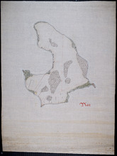
Plan of Lennox Island: Incomplete
Description: Plan of Lennox Island. Incomplete. Shows water and foliage.
Province: Prince Edward Island
Type: cadastral maps
Sketch of parts of Lots 4 and 5
Description: Sketch of parts of Lots 4 and 5. Area along Mill River(?). Shown are lots, and water.
Province: Prince Edward Island
Type: cadastral maps
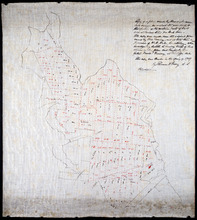
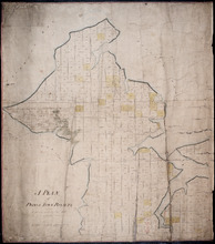
Plan of Township No. 7 the property of R.Bruce Stewart: Drawn by R. Stewart 1861 from survey by A.…
Description: Plan of Lot 7. The property of R. Bruce Stewart (No.23). Surveyed by A. Anderson and others, and drawn by R. Stewart. The map shows lots, residents, and roads.
Province: Prince Edward Island
Type: cadastral maps
Date Created: 1861

Plan of marsh lands on the two sides of the Pisquid River
Description: Plan of marsh lands on the two sides of the Pisquid River. Lot 37. (No.68, Queens Co.) The map shows lots, residents, measurements, and acerage.
Province: Prince Edward Island
Type: cadastral maps
Date Created: 1897-12
Plan of Lot 31
Description: Plan of Lot 31 (No.2). Mainly outline. Shows Refugee Share drawn for in Council, 12 February, 1784. Signed by John Russell Spence, Clerk of the Council.
Province: Prince Edward Island
Type: cadastral maps
Date Created: 1784
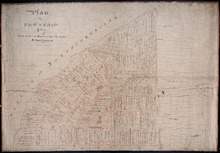
A Plan of Prince Town Royalty: from A Survey made in Nov. 1828
Description: A plan of Prince Town Royalty. Also shows Prince Town. Gives numbers of Town and Royalty Lots. The map shows bodies of water, squares, and towns.
Province: Prince Edward Island
Type: cadastral maps
Date Created: 1828-11
Plan of Township No. 7: Copied from the the Survey of John Clan L.S>
Description: Plan of Lot 7 (No.22). Stewart Estate. Shows names of residents, acreage, and references to land conveyance, roads, and bodies of water. Plan copied by Owen Curtis.
Province: Prince Edward Island
Type: cadastral maps

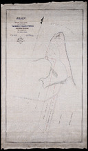
A Trace of West Coast, Prince Edward Island: from the Survey by Capt. Bayfield, R.N. furnished at…
Description: Plan of the West Coast of Prince Edward Island from the survey by Capt. Bayfield furnished at the request of a Committee of the House of Assembly, March 18, 1842. The coast line marked in red has… more
Province: Prince Edward Island
Type: cadastral maps
Date Created: 1842
Tracing of Plan of the North Moiety of Township No. 26: The property of the Messrs Thompson of…
Description: Tracing of Plan of the North Moiety of Lot 26, the property of the Messrs. Thompson of Belfast, Ireland. Documents attached. The map shows lots, residents, roads, acreage, and bodies of water.
Province: Prince Edward Island
Type: cadastral maps
Date Created: 1875-11-05
Proposed New Road from Chapel Road: To Road leading to Grand River Beach Road
Description: Plan of proposed New Road from Chapel Road to road leading to Grand River Beach Road. Total distance 2.16 miles. (No.47) The map shows residents, lots, roads, and foliage.
Province: Prince Edward Island
Type: cadastral maps