Displaying 28 - 30 of 30
Plan of the French Marsh: Lot 37 - No. 10
Description: Plan of part of Lot 37 (Nos. 10 and 58). This item consists of three maps on three separate sheets, all showing the same area. The maps show the French Marsh on the north side of the Hillsborough… more
Province: Prince Edward Island
Type: cadastral maps, topographic maps
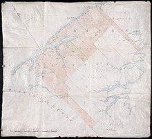
Plan of Lots 38, 39, 40, 41, 42, 66 and part of Lot 43
Description: The map shows some of the lots and parishes in a northern portion of Kings County. It shows Savage Harbour, St. Peter's Bay, rivers, streams, mills, roads, buildings and churches. The map has a… more
Province: Prince Edward Island
Type: topographic maps
Plan of Prince Edward Island showing the names of the Proprietors
Description: Plan of Prince Edward Island showing the names of the Proprietors, their acreage, and the number of settlers on their property. The map shows Prince Edward Island divided into the 67 lots established… more
Province: Prince Edward Island
Type: topographic maps