Displaying 1 - 2 of 2
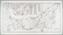
A Map of the Island of St. John in the Gulf of St. Laurence: Divided into Counties and Parishes and…
Description: The map shows the province of Prince Edward Island, but known to this map as St. John, and its counties. Shown are bodies of water, lots, cities, towns. roads, buildings, and Islands.
Type: topographic maps
Date Created: 1775-04-06

L'ACADIE: Par le Sr. Robert de Vaugindy Fils de Mr. Robert Geogr. ord, du Roy, Avec Privilege
Description: Period designation 18th century. The map shows bodies of water such as Baye Francoise, villages, towns, cities, mountains, trees, islands, and banks.
Province: Nova Scotia, Prince Edward Island
Type: topographic maps
Date Created: Unknown year in the century of the 1700s